Injidup Natural Spa Rock Pool Drone Photo

Injidup Natural Spa, Wyadup Rocks, Yallingup – Western Australia, Australia

HOW TO FIND INJIDUP NATURAL SPA & TIPS BEFORE YOU GO

Crystal clear waters. Wild, thick waves. A make-shift waterfall. A hidden rock pool treasure. The beauty that is, Injidup Natural Spa at Wyadup Rocks, Yallingup.

Injidup Natural Spa Rock Pool Drone Photo

While not technically a waterfall, there is a place where the ocean meets the land. Where wild rocks have moulded into a water-fall like formation. The water from the ocean crashes over the top of these rocks, and gushes down into the crystal clear pools near the beach. A beach water-fall, if you like. This is Injidup Natural Spa.

Getting there

Injidup Natural Spa is a highly sort after spot for West Australian’s delving into the beautiful South-West region. A must-visit if you’re ever close by. And if you know where you are going, it’s not too hard to find (you have to be pretty good at manoeuvring over rocks, though).

Driving down Caves Road, away from Yallingup you need to turn (right) onto Wyadup Road. Now this is where it gets confusing, if you refer to the map below it shows Injidup Beach as being further down, along Cape Clairault Road. Ignore this. Follow Wyadup Road until the very end, which will curve around to the right. Here, you’ll find a relatively small and not-very-well-structured carpark. (I’ve marked it on the map with a red circle). You may have to pull up on the edge of the gravel if it’s a busy day.

screen-shot-2017-01-09-at-9-23-37-am
Road Map. Wyadup Road. Google Maps (2016).

Once at the carpark, there is no real or clear path down to what is known as “Injidup Natural Spa”, but a few thin, windy dirt tracks. These begin off to the left and allow you to pick and choose your preferred route. After the initial descent, it is a lot of people’s first instinct to head to the left, towards where you can see visible, white sand. However, if you continue down to the right (which will turn into precarious rocks) you will find the sanctuary. 

Below you can see the ‘falls’, where huge waves from the ocean on the other side collide with the rocks, sending a wash of white water and spray over to this pool. Water trickles (or violently washes, depending on the size of the wave) down the grooves in the rock. And voila, waterfall! Or close enough.

What to bring

I’d suggest bringing along some good-grip sand shoes as opposed to thongs or sandals. However, I find the easiest way is actually with bare feet, using my toes to curl and grip and dance along the rocks, aiding my balance on the rocky terrain. Up to you, though.

It’s also imperative you bring along some sunscreen, a water bottle, towel, and of course, don’t forget your bathers. You’ll want to swim in the crystal clear waters, no matter how cold they are. Trust me.

15934532_10210346775918614_1349436441_n

As you can see, Injidup Natural Spa has become quite a popular spot, so there’s not a lot of privacy or opportunity for a people-less picture. At least not in the summer months, anyway. I mean, you can try your best and wait very patiently. Either that, or get up at 4am and venture for sunrise for a quiet shot.

Leave no trace

Another sad thing I noticed on a recent trip is the amount of rubbish left behind. Clothes, beer bottles, you name it, lie in the sand and in rock crevices. This sanctury will only last if we look after it. So please – LEAVE NO TRACE. Take your rubbish with you and help preserve this beautiful place so we can all enjoy it for years to come. 

Injidup Rock Pool with no waves, calm and clear water

But wait, there's more!

After doing my own exploring with friends, I found a quiet, peaceful rock pool tucked away in the endless mountains of rock. Now I won’t give away exactly where you need to go to find this one, because there needs to be some element of mystery, but if you (carefully) go exploring among the rock-mountains, I promise you will not be disappointed. Read more about my opinion on secret versus share phenomenon here. 

Girl climbing into blue rock pool
Mermaid in a rock pool taken from drone above
secretpoolyallingup2

thumb_img_4736_1024

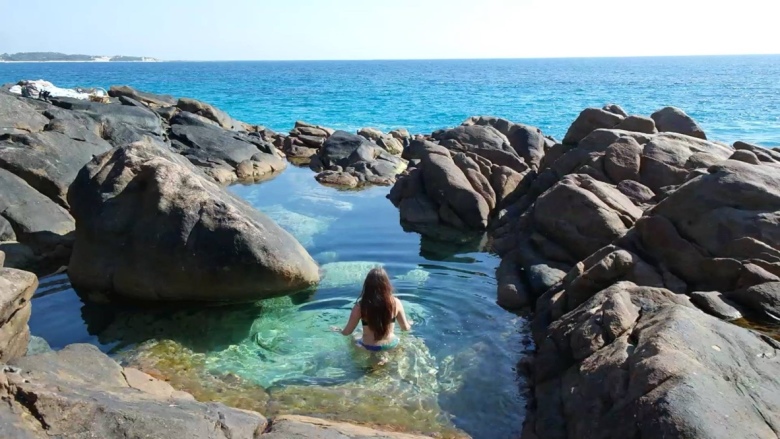
Magical, right? I have no other words.

Quick Facts

Last visitSeptember 2019
Best TimeSeptember – March
Start / FinishWyadup Road Carpark, Injidup Beach
Unsealed RoadsNo
Walking distanceless than 100m from carpark
Time3hr drive from Perth
DifficultyEasy
FacilitiesNone
Lat & Longn/a
NearbyBoranup Forest
WatercourseIndian Ocean
Want to Subscribe?

Never miss out on an adventure by entering your email below!

Kathmandu
An image of a girl in a kimono and hat looking out to azure blue waters of Black Diamond Lake

Black Diamond Lake, Collie – Western Australia

HOW TO FIND BLACK DIAMOND LAKE & TIPS BEFORE YOU GO

Ever since I saw a photograph of the pristine, bright crystal-blue water of Black Diamond Lake, I wanted to go there.

I mean, look at it.

15991725_10210402590313939_1485170358_o

Friends and I talked about going to Black Diamond Lake, throwing around ideas about road trips and camping trips and the works, but of course, they never actually got put into motion.

While holidaying in Australia’s South West, I decided to change that. I sent my friend Morgan the message – something along the lines of “WE STILL HAVE TO GO TO BLACK DIAMOND LAKE – BEFORE I GO!!!” And Morgz, being the enthusiastic person that she is, said ‘Yep, what about Thursday?’ And that was that.

15978176_10210402591233962_1404490344_n

Black Diamond Lake is located in Allanson, a community only 5km or so from the town known as Collie, roughly 190km from Perth.

Morgan drove down from Perth, and I drove up from Busselton. My trip was an hour and a half, while hers 2 hours or so. Either way, the lake isn’t too difficult to get to – Ferguson Road, the road the lake resides by, comes directly off Coalfields Highway, so there’s not a lot of fluffing about in small country-town roads.

Screen Shot 2017-01-16 at 2.26.52 PM.png
Road Map. Black Diamond Lake, Allanson. Google Maps (2017).

I actually visited Black Diamond on the same day I did Barrabup Pool, so I won’t go into the details of the way I went. But if you’re traveling from Perth, take Kwinana Freeway South until it turns into Forrest Highway and eventually continue onto Old Coast Road. Then turn left onto Raymond Road, which you follow until you hit South Western Highway, at which point turn left and then a quick right into Coalfields – and then you’re on your way to Ferguson!

Screen Shot 2017-01-16 at 2.26.27 PM.png
Road Map. Raymond Road to Coalfields Highway. Google Maps (2017).

Once you’ve turned into Ferguson (a right turn onto an unsealed road), keep following for about 600m and you’ll see the first glimpse of the lake. Continue until you come to the first carpark on the right (it will be very obvious). There is lots of parking space there and easy access into the lake.

15967568_10210402591153960_37477852_o

For those that don’t know, Black Diamond was formerly an open cut mine site that ceased operation in the 1950s and has since been filled with water.

Now it is probably at this point that I should mention the danger of the presence of amoeba in the water. There have been a few warnings issued about the water quality at Black Diamond – all the information you need can be found on the council’s report and also an article by WA today. (FYI, I put my head under the water and I’m still here kicking).
However, it is best to have all the info and make your own educated decision before you go.

I would recommend going on a really sunny, cloudless day, because this is when the water will look its best, shining the beautiful azure blue colour.

15992014_10210402590713949_464154993_o

On the opposite side of the lake to the carpark, there’s a rope swing tied to a big tree. We couldn’t help ourselves – we had to have a turn. Though I would advise to jump directly straight and land on your feet, as it is very shallow on either side of this bank (and only if you’re willing to put your head under).

15978508_10210402594674048_505383986_n

In terms of picnicking, the best idea I’ve seen was those who took tarps to use as shades between two cars (generally utes, but you could make do), or small tents, picnic rugs and tables and chairs. There’s not a lot of shade space at the lake, so get creative with your choice of gear and remember to Slip, Slop, Slap!

16010618_10210402597114109_1242520635_o

We made a full day-trip out of being at the lake. Eskies, rugs, you name it. It was such a beautiful setting, even just to sit and observe.

We found a limestone rock to set up our stuff on, rather than being down on the bank with everyone else around us. The rock gave us a higher view of the lake, but not so high that we couldn’t easily enter the water. It was the perfect setting.

15967702_10210402596754100_1343772317_o

It was a scorching 37 degrees (probably more in direct sunlight) on the day that we went, so we escaped into the cool water, lounging around on blow-up mattresses, watermelons, pineapples and various birds for most of the time.

16009782_10210402595834077_305343485_o

15995502_10210402595314064_919404181_n

15991357_10210402596034082_58684684_o

Would you believe me if  I said that photos don’t even do this place justice?

It is another one of this world’s wonders that is worth seeing – especially when we don’t know how long we will be able to continue to visit, swim and enjoy the lake for.

I’m glad we made the trip.

15978604_10210402591353965_2039035381_n

Quick Facts

Last visitDecember 2018
Best TimeSeptember – March
Start / FinishFerguson Road
Unsealed RoadsYes, good condition can be managed in 2WD.
Walking distanceless than 100m from carpark
Time3hr drive from Perth
DifficultyEasy
FacilitiesNone
Lat & Longn/a
NearbyBarrabup Pool, Collie town
Watercoursen/a
Want to Subscribe?

Never miss out on an adventure by entering your email below!

Kathmandu

John Forrest National Park Falls, John Forrest National Park, Perth – Western Australia, Australia

Exploring Perth Hills will always bring satisfaction when it comes to waterfalls, and the National Park Falls up at John Forrest are no exception.

John Forrest National Park is Perth’s oldest National Park, about 25-30 minutes out of Perth CBD. Plenty of information on how to get to the falls can be found here.

However, I have a secret short-cut. Travel along Great Eastern Highway Bypass, then exit left at Roe Highway and turn right onto Morrison Road. Follow this until you come across a round-about with a small car park to the left (this is called Pechey Road Carpark).

From here, you can walk towards the Swan View Tunnel (keeping to the right on the gravel path) and follow that towards the falls.

Road Map to John Forrest National Park. Google Maps (2016).
Map of Swan View Tunnel and National Park Falls (walking trails not shown). Google Maps (2016).

I visited the park on my own, strolling along the orange dusty gravel track, admiring the clear blue sky and the sunshine, the view of the million-shades-of-green landscape and whatever insect or bird that flitted by.

Keep to the right for the tunnel, the left to avoid.

I walked through the old railway tunnel, shining my torch on the old faded bricks, and wobbling over stones, trying to avoid muddy slush. Without the torch, you see nothing, but the bright, distant light ahead distorting how much farther you still have to travel.

 
The beginning of the tunnel…

Inside the tunnel looking back…

Looking how far until the exit of the tunnel…

Out of the tunnel, I then headed for the falls, where a small wooden bridge takes you over the very top rocks. To get to the bottom, you have to continue up to higher ground, and veer left onto the gravel walking trail. These trails are marked only with wooden stumps with an outline of an eagle bolted to them. It is slim and steep, so wear proper shoes and remember to be on the look out for snakes and sharp shrubs.
 
Once down at the bottom, there’s the viewing platform smack-bang in the middle. I, however, prefer to generally “Bear Grylls” my way around the smooth, red rocks and gushing stream. It was a magical day for me – though probably a bit late in the year, as the falls were not as full as they would be in June-September (this visit was around November).
Photo above is taken from the very bottom of the waterfall.

As you can see, the falls weren’t flowing extensively from the top during my visit, so I will definitely be returning in the winter months. Though the weather on the day I went was incredible, so I can’t complain about that.

I managed to return to John Forest National Park Falls in October 2017, and while they were flowing a bit better (check out the photos below!), I still recommend a winter visit. 

Quick Facts

Last visit October 2017
Best Time July-October
Start / Finish Pechey Road Carpark
Unsealed Roads No
Walking distance 2km return
Time 1hr
Difficulty Easy, take torch if going through tunnel
FacilitiesNone this way, Picnic area other side
Lat & Long unknown
Nearby Hovea Falls
Watercourse Jane Brook

Want to subscribe?

Never miss out on a waterfall chase by entering your email below!

Recent Posts

Find me on Facebook

Lesmurdie Falls, Mundy Regional Park, Perth – Western Australia, Australia

I was on my flight home to Perth, settled into my aisle seat with a scratchy Qantas blanket and puffy pillow (I always wonder if they wash those things or chuck them out, but it’s probably best not to think about it). In any case, I was relatively comfortable, apart from freaking out about the possibility of the plane crashing, like I always do when I’m on a flight. Irrational, really. But a fear all the same.

The plane shuddered slightly and my stomach flip-flopped. But then they served dinner, a steamy butter chicken with rice, and I organised my tray table – cup on the right for wine, cup on the left for tea, rubbish in the seat pocket so it’s out of the way, you know the drill. The hippie girl next to me smelled like smoke and spilled her red wine all over my foot, but other than that it was a good flight.

Halfway through, it hit me. I was going home. I didn’t really want to go home (even if it was just for a weekend), other than to see my family for hugs and kisses and maybe a hot cross bun or two (or five). I wasn’t quite ready to be back in my old room, back in that old routine. So I thought I better get a wriggle on with making plans to keep myself busy. That’s when Lesmurdie falls came to mind. I hadn’t had a chance to visit them before I left my home town, and what better way to spend some quality time with Mum than on a bush hike? I’m not sure she agreed, but I dragged her along anyway.

How to get there: 

Lesmurdie is located in the Shire of Kalamunda, also known as ‘Up in the Hills’ in Perth jargon. It’s practically the only part of Perth that isn’t deadpan flat. But anyway. The falls are in Lesmurdie – hence Lesmurdie Falls (thanks captain obvious), and are relatively easy to get to.

They are best accessed from Welshpool Road East, or Kalamunda Road, depending on where you are coming from. I’ve only outlined Welshpool Road directions because it’s the way we went.

Road Map to Lesmurdie Falls. Google Maps (2017).

From Welshpool Road:
Right or Left (depending which way you’re travelling) into Gladys Road.
Left into George Road.
Follow George Road as it curves around to the right, until you reach Ford Road.
Turn left onto Ford Road.
You’ll reach a fork in the road.
Turn right onto Nelson crescent.
Follow Nelson crescent until you hit Falls road.
Turn left into Falls road – this will be a ‘No Through Road’, but you’ll see the carpark before you reach the dead-end.
Congrats! You’ve arrived! See? Easy.

So Mum and I arrived. Up at the top of the falls, we had a steep descent ahead of us. There are a few hiking trails to choose from, the sign at the beginning of the trail will show you where each one goes and how long it will take. After a little uhmming and ahhing, we decided to take The Falls Trail – only a 640m return. I desperately wanted to manoeuvre to the bottom of the falls to watch them flow, and The Foot of the Falls trail is a continuation of The Falls Trail, so that was a win-win for me.

The walk is a relatively easy one, and we made our way leisurely, following the signs along the way. Luckily, you don’t have to be a rocket scientist to find your way to these falls. Soon enough, we reached the peak where the view overlooking Perth and the city is simply phenomenal. If anything, you should visit these falls to stare out at that.

It was 27 degrees but it felt more like thirty-something as we walked, sweat trickling down my back between my backpack and my shoulder blades. There wasn’t a whisp of wind in the air, but you couldn’t complain about the weather. Not when it produced views like this.

There are two lookout spots made of metal frames –  what I assume is the end of The Falls Trail. We reached these and peered down at the valley from the top of the waterfall. The falls were fairly dry, a testament to this time of the year in Perth. We were lucky they were flowing at all, really, probably due to the heavy rainfall which recorded the wettest day ever in February.

Photo taken in April 2017

I tried my best to get good photographs of the falls, which undulate down the steep slopes. I ventured further down the pathway, stepped onto precarious rocks and bent my knees in typical ‘photographer’ stance. But it was no use, the lighting wasn’t doing the scene any justice. So we made the split decision to continue to The Foot of the Falls (2km return).

If you don’t like stairs, this trail is definitely not for you. Wide wooden steps of orangey-red dirt lead the way towards the bottom of the falls.

A thin, dry, gravel path then winds its way through shrubs, seemingly taking you in the complete wrong direction. Trust me, you’re headed the right way.

Soon, we reached a fork in the road and pondered over the huge descent. Hint: you want to follow the path down to the right, until you pass another carpark. There wasn’t any signage at this point, so it was a bit of a gamble. I guess it’s all part of the adventure.

My shoes kept slipping on the gravel and we giggled amidst a series of “Did you have a nice trip?” and “You didn’t send me a postcard!” But in all seriousness, maybe wear some shoes that have a bit of grip to them. Apparently my old sneakers have decided they’ve had enough of being grippy.

Finally, we reached the smoother path that resides next to the riverbank, listening to the calm trickle of water as it gradually became louder. I skipped with excitement – we were almost there.

It seemed as though the windy river would never end. Animals rustled the bushes nearby, bees hummed in the distance. We took it all in as we walked.

I love how every time you go on a nature walk, it will never be the same again. Things are ever-changing, and that’s what makes the experience so worthwhile. You just have to stop when you’re going to admire things, otherwise you can’t see the uneven ground below you and you’ll end up tripping again. Which is embarrassing, trust me.

Just when I thought we’d never make it, BOOM, there they were. Lesmurdie Falls. We could see the lookouts that we had come from, and thin sprays of water flowing down the rock-face, which is a lot steeper than it looks in photographs.

I tip-toed over cobbled rocks like stepping-stones, working my way towards the water. Mum was less eager, but eventually found her way. Our glutes were sore, our shoulders were red & raw (sunscreen: would recommend) and we were puffing, deep breaths from our lungs. We chugged down water that had warmed inside our plastic bottles. But we had made it.

There’s something triumphant about finally finding the falls. It’s like the reward you get for doing some damn hard-work. You can sit, or stand, and admire them for a little while, taking it all in and congratulating yourself for making it.

Or, if you’re like me, you can kick off your shoes, toss out your hair and jump straight under the fresh, clean water – fully clothed, might I add. Yeah, I’m crazy. But it was hot, and we’d made it this far. I wasn’t about to leave without experiencing the falls first-hand.

The water flow was stronger than I realised, and I had to carefully slide myself along mossy, slippery rocks, feeling for secure cracks and dips for my feet to rest. It’s dangerous, don’t get me wrong, but it’s a thrill I can’t replace. Ironic really, since I can’t even sit on an aeroplane without freaking out. It’s far more dangerous to climb slippery, rocky slopes than it is to sit on an aircraft. But I digress.

The icy cold water soaked me through – I just laughed and spluttered and threw my arms in the air, feeling the rush of water clean out my fingernails and wash through my hair.

It certainly cooled me off for the trek back to the top. And boy oh boy, a trek it was. You forget when you’re going downhill that you’ll have to go back up. My wet clothes clung to me and kept me from overheating, trudging uphill for what felt like forever (my iPhone tells me it was 30 flights of stairs, but who knows how accurate that really is). We made it, though, obviously, or I wouldn’t have lived to tell this tale. But it was worth every step.

I have since returned to Lesmurdie Falls in October, and they look mighty different after winter! Check out the pics below!

Quick Facts

Last visit October 2017
Best Time July-September
Start / Finish Lesmurdie Falls Carpark
Unsealed Roads No
Walking distance Falls Trail 640m return, Foot of Falls 2km return
Time Allow 2hrs
Difficulty Moderate
Facilities Picnic tables, Toilets
Lat & Long 31.9943° S, 116.0337° E
Nearby Shire of Kalamunda
Watercourse Lesmurdie Brook

Want to subscribe?

Never miss out on a waterfall chase by entering your email below!

Recent Posts

Find me on Facebook

Serpentine Falls – Western Australia, Australia

A small water sanctuary, just South-East of Perth, Western Australia lies Serpentine Falls, where we can frolic and play in nature’s pool.

(Hot Dogs Or Legs? Hehe).

Serpentine Falls are located about 55km South-east of Perth, WA. The drive is quite easy really (approximately 1 hr and 10 minutes from the city), though you may miss the final turn off if you aren’t careful.

If you are coming from Perth City, head straight down Kwinana Freeway. You will then get to turn onto a typically (and hilariously) Aussie-named exit – are you ready for this? – Mundjidong Road, which will eventually reach South Western Highway. (If you’re coming up to the falls from the South, anywhere past the Baldivis kind of area then you will exit the Freeway onto Karnup Road, which also hits South Western Highway.

Either way, turn right onto South Western Highway and if you came from Mundjidong, follow that for another 25km’s or so and you’ll find Falls Road. If you’re coming from Karnup, Falls Road will be right opposite you. Like I said, it’s easy to miss, so be on the look out on your left for a tiny little could-you-even-call-it-that service station, and the Serpentine Park Home Village next door. You’ll find it eventually, trust.

Road Map. Serpentine Falls. Google Maps (2016).

The only not-so-great-thing about these falls is that you have to pay $12 entry if you are in a vehicle. But that goes to maintaining the park, wildlife and facilities. So it’s not so bad, really.

The carpark area is also surrounded by park benches and a picnic area, so it’s a great spot to take some food and friends and enjoy being with nature. Though word of warning – the kangaroos are not shy, and will definitely try and join you.

The Serpentine Park is a great spot for bush walking – and if you’re up for the trek, you can find your way to the top of the falls. But for those lesser inclined to go hiking – you can simply embark on the short, easy walk to the falls pool (off to the right of the overflow carpark area – which is to the left of the picnic area). If you want more info, you can visit The Department of Parks and Wildlife.

Now – to the falls!

The falls are small, but beautiful. A perfect place to relax on the rocks, or glide through the (freezing cold, might I add) water.

If you visit in the summer months, the falls will likely not be flowing very much, or at all. But it is a great time of the year for swimming in the pool. The winter months are an awesome time to see the falls flowing at their full capacity, but it will be far too cold to venture into the water.

Although, I wish I could say that it goes without saying, but it doesn’t: Be Careful. This tiny sanctuary has had 12 deaths due to people underestimating how shallow it really is. So basically, don’t go leaping off the rocks. Simply sit back, be smart, and enjoy the fact that we get to experience these 100 year-old falls in the first place.

Quick Facts

Last visit October 2017
Best TimeNov-Feb for swimming, June/July for water flow
Start / FinishSerpentine National Park Falls Rd Carpark open 8.30am-5pm, plan arrival before 10am. $13 entry for vehicles.
Unsealed Roads No
Walking distance 400meters
Time 5mins
Difficulty Easy
Facilities BBQs, Picnic Tables and Toilets
Lat & Long 32.3679° S, 116.0110° E
Nearby Serpentine Camping Centre, Millbrook Winery
Watercourse Serpentine River

Want to subscribe?

Never miss out on a waterfall chase by entering your email below!

Recent Posts

Find me on Facebook