Sheoak Falls, Great Ocean Road, Lorne – Victoria, Australia

My muscles were aching.

I stretched back in the driver’s seat and pushed my foot on the accelerator. I was determined to get to Sheoak falls – the second falls of the day – before sunset.

My friend Morgan and I had exhausted ourselves visiting Erskine Falls earlier in the day, but I wasn’t about to let that get the better of me. Our shoes were muddy and wet, laid out on my rain jacket in the boot, leaving us in soaked-through socks. Our hair was mangled onto our foreheads, my jeans were filthy, and I was starving, but we ventured on.

The view from a stopping bay on Great Ocean Road, Lorne.

The sun was already beginning to set, which made me anxious. But it made for a very pretty drive along Great Ocean Road, and Sheoak falls are only 5km from Lorne (we were staying at Lorne Foreshore Caravan Park), so in reality we had plenty of time. Or so I thought.

Directions to Sheoak Falls:
If you type “Sheoak Falls” into Google, it will tell you they’re right next to the carpark, as per the below.

Sheoak Falls Carpark. Google Maps (2017).

However, they’re actually more like where I’ve put the location tag in the image below. The carpark comes straight off Great Ocean Road, though, so it’s not hard to find your starting point.

Road Map. Google Maps (2017).

We soon came across the small car park off to the right (which is well sign-posted). However, once we were there, it wasn’t obvious which direction would actually lead us to the falls. Then we found the sign below, next to a mulch track off to the left.

I’d also heard Sheoak Falls were fairly easy to access, so we decided to hedge our bets. We jammed our feet back into our muddy shoes, waved goodbye to little Suzie and headed uphill on the mulch track.

The view of the carpark from the track (behind us).

Turns out I had heard correctly, and it was a pretty easy and basic track along a wooden boardwalk through shrubs and bush. My feet made the wood creak as I plodded along in the chilly air, taking in my surroundings.

The great, unique thing about these falls is having a view of the ocean as you walk. With green cliff scenery on one side, and the windy road with turquoise sea on the other, we were quite content.

It doesn’t last forever, though, and soon we had to deviate down some stairs and inland towards the falls.

We began the descent, taking each step slowly and one-at-a-time. And just as well – my heart nearly leapt out of my throat when I placed my foot on the 12th step from the bottom, which ricocheted forwards. I stumbled down the next few steps, but regained my balance without face-planting. Luckily.

It was minuscule in the scheme of things, but it made me giggle. This is one of the reasons I write my blog – to give people the tips and tricks they would never get from a National Park website. So, yeah, beware of the 12th step from the bottom! *Update* As at September 2017, this has been fixed.

Once I had tackled ‘death by wobbly step’, we reached a long, skinny concrete path that leads into the valley.

I’m quite surprised at how quickly we walked, considering how tired we were from all the day’s adventures (which you can read more about here). But time was of the essence and we wanted to make it to the falls before the sun disappeared behind the cliffs and left us in darkness.

Not to mention without the ability to take photos – I know! Disaster, right? If we couldn’t take pics – how would anyone know that we went!? It’s sad, but true. Ah, but really we just like to capture the beauty. Check out my Instagram for more!

So anyway, when we were faced with more stairs, we only moaned a little before charging upwards. What’s that saying? When the going gets tough, the tough gets going?

Still, the track to these falls is relatively simple and the stairs do exist for your aid. I just have a thing about stairs. My glutes twinged with each step, tightening almost to the point of cramping. I have a love/hate relationship with the feeling. I mean, on one hand you know it’s helping tone those butt-muscles we all want so badly. But on the other, well, it bloody hurts!

We made it, though. If even through clenched teeth. As you can see, these falls are not as commercialised as some of the others in the area, which makes them pretty special.

The uncommercialisegd, basic-as track I'm talking about.

Suddenly, we could see a glimpse of the falls peaking through the trees, and I got excited, clapping and carrying on.
“I can spy the falls, I see the falls, I’m going to some falls,” I chanted to Morgan. She just laughed at me in response.

It’s kind of childish how giddy I get when I see how close we are to flowing water, but I’m not ashamed. It’s part of what makes me who I am.

The view of the river from above.

Not long after seeing a glimpse of the falls, we reached a fork in the road. You can choose to head to the top of the falls or the bottom – though it’s not sign posted (bit obvious though, right?)

Seeing as we were quickly running out of daylight – I swear the sun is running a race when it begins to set – we decided to head downhill. It was a good choice. To read more about what’s up the stairs, Swallow Cave Falls, click here.

The bottom of these falls is an intimate area surrounded by gorge, which creates a stunning little hub to admire and take the photographs we so desperately wanted.

The air was completely still. It was crisp. There was nothing but the sound of the water running down the rock face. Green ferns bloomed at the water’s edge, which was murky and deep. I let out a sigh at its beauty.

Turns out the loss of sunlight was actually a great thing, because it allowed for some stunning photos tinged with hues of blue, and without the glare of the sun behind the rocks.

Now here’s where my craziness creeps in. I brought my favourite Wittner knee-high boots with me in order to get the perfect ‘Instagram’ shot. It’s absurd, really, how we all struggle to do something different for social media. I mean, what are we trying to prove? Well, ultimately that we are trendy and can take cool pictures. But to be honest with you, I just really like my boots.

I’m thinking Wittner should hire me as their model though, right? Just kidding.

Really this was the ultimate test to see how well I could balance and hop on squelchy mud without ruining suede. Risky, but fun.

I enjoyed the fact that different angles gave different lighting and mood to the pictures of these falls. I could’ve admired them forever.It was so quiet and peaceful in the gorge, especially since we had ventured out so late. This was at about 5.30pm, so we had the place all to ourselves.

After taking the time to simply admire the falls, I decided to explore further.

I love to get as close to waterfalls as humanely possible. This usually consists of diving right into freezing pools, or sitting directly under the falls themselves. However, it was literally way too cold for any such business during this time in April/May. So I had to settle for scaling the rock face instead. As you do.

I also re-visted these falls in September 2017 on a day when they were tranquil and beautiful, and then two days later after heavy rainfall and storms. It will never cease to amaze me just how powerful nature is, and how a place is never the same when you return. 

The falls on a day in September 2017
The falls two days later in September 2017

I’ve probably overloaded you with photos, but I couldn’t help it. This place was just too beautiful not to share every single one.

If you’re looking for a quick and easy trip to a gorgeous sight-to-see, these are the falls for you. They certainly kept a grin on my face.

On my recent trip in September 2017, I decided to venture further up the stairs, and captured the view of Sheoak from above. I also made my way up to Swallow Cave to the Upper Falls – check them out!

Quick Facts

Last visit September 2017
Best Time July-September
Start / Finish Sheoak Falls Carpark
Unsealed Roads No
Walking distance1km return 
Time 30min return
Difficulty Easy
Facilities None
Lat & Long 38.5653° S, 143.9628° E
NearbyLorne town centre, Phantom Falls, Henderson Falls, Won Wondah Falls, Cora Lynn Cascades, Erskine Falls, Straw Falls, Splitter Falls
Watercourse Sheoak Creek

Want to subscribe?

Never miss out on a waterfall chase by entering your email below!

Recent Posts

Find me on Facebook

Cora Lynn Cascades, Great Otway National Park, Lorne – Victoria, Australia

I woke up groggily.

A warm blanket was wrapped around me at Lorne Foreshore Caravan Park. I shifted my feet, my body stiff from a night’s sleep in an unfamiliar bed. A good sleep, though. Thankfully. My friend Morgan and I had a full day ahead of us.

We were headed to Cora Lynn Cascades, not too far from where we were the day before at Erskine falls. Google Maps told us it was only 8 minutes away, but when the automated voice said “you have arrived at your destination”, we were travelling along Erskine Falls Road and there was no clear stopping bay, so it was definitely incorrect.

Road Map. Google Maps (2017).

If you just keep driving a tad further, you’ll reach a small carpark off to the left named Blanket Leaf Carpark – this is where you need to begin.

I’ve marked it on the map below with a red circle. The end of the blue line is where the navigation will tell you to stop (probably because it’s the closest point to the falls). But it is wrong! I know, what an idiot, right?

Road Map. Google Maps (2017).

Nah but to be fair, we arrived easily. The carpark is right next to the road and a small picnic area, so my advice would be to secure your valuables or take them with you.

Once that’s all out of the way, it’s pretty clear as to which direction you need to walk – a track begins near the picnic area (which also has some tables & toilet facilities – granted they’re drop toilets, so not the nicest things on Earth, but hey, good to know all the same).

Once we began the track, we entered a world of green. Ferns and trees overtook the path with such beauty. It’s funny to realise that even as a writer, sometimes I still manage to be lost for words. But seriously. Just look at this greenery!

Now while it did look stunning, there was a downside. Heavy rainfall overnight had soaked the track through.

In fact it wasn’t much of a track at all, as much as it was a mud-bath-like consistency. And if that wasn’t enough, the vast majority of the trek was down extremely steep slopes. Safe to say we had a very slippery, squelchy 2.1km descent.

It made things very interesting, and each step was a risk. BUT, I’ve mastered the art of this. Hear me out. The key is to distribute your weight evenly onto your foot, with each step being a very careful, precise choice. Trust me. Take your time. If you fail to do this, you’ll slide drastically in the squelchy mud and almost feel your heart leap out of your throat in the process. This may make the trip longer than the estimated 1.5 – 2 hour return, but it’s better than covering yourself in mud.

Tip: step where there are thick leaves, or on the edges of the path to try and avoid slipping. Key word: try. You might still end up on your bum. I can’t promise anything.

You will also probably want to wear proper hiking boots. Or, you could be fun like us and trek in cowboy boots or a pair of Nike free-runs. All I’m saying – it’s doable either way.

Although you’ll probably be ready to throw out the Nike’s once you’re done (especially if you go in the wet season, we were here around May and winter was well on it’s way).

Aside from the slippery, muddy slopes threatening to have us fall flat on our faces, the track wasn’t too bad. It was well sign-posted so you always knew which way to turn.

The above image is referring to the track that leads to Phantom falls (a 7km circuit) and is very strenuous. Unfortunately we didn’t have time to complete this as we had to get on the road back to Melbourne that day, but if you’re interested you can find more information on a very helpful PDF here. It’s actually one of the best documents I’ve seen on finding waterfalls. Yay for Great Otway National Park!

Anyway, like I said, it’s well sign-posted. You can also deviate and take Lemonade Creek Track to Erskine falls if you’re a keen hiker (which is roughly 4km one way).

We, however, were well on our way to Cora Lynn Cascades, so we continued through the squelchy mud.

Remember to watch out for fallen trees and debris. The weather conditions here can be unpredictable, so you’ve got to keep awake and alert at all times.

As well as the bright green areas, there was also dark gloomy moss when ducking under shrubs and delving over bridges. It really felt like we were in a different world.

Narnia? Maybe.

I loved how there was green in every shade – how the light dazzled when the sun came trickling through the trees. I think green is my favourite colour. I mean, how can it not be when it looks like this?

We then reached another ominous bridge – how far were we? There was no way to know.

There are two bridges along this trail, both crossing a small section of the Cora Lynn Creek.

We trekked out from the darkness and into more bright terrain, where there was plenty of wildlife to observe.

Spotted: A little birdy with a yellow breast perching on a skinny tree. He was in a rush to get somewhere, perhaps to find a young female birdy to play with. Let's hope he's not two-timing! Xo Xo, Gossip Girl.

Suddenly, we reached some steps which we thought must be a good sign, especially after such a long time spent on a thin muddy trail that had us wondering if we were EVER going to reach the falls.

But we were right, and finally the cascades peaked through the ferns.

However, sadly these cascades were not our end-destination. These appeared to be the beginning of the cascades, to which access is very limited.

This was the best shot I could get through the thick, wet greenery.

Unfortunately it was far too slippery and dangerous for us to get to these, but I have seen photographs of people at them so it must be possible on drier days.

I did give it a go, but it was way too slippery and I was worried I wouldn’t make it back up the bank. So I didn’t risk it.

If you continue further, walking along a mossy fallen log and down a skinny path, you’ll reach the steps leading to the ‘official’ cascades.

Down, down, down we go. Gently down the steps. Merrily, merrily, merrily, merrily, oh yes…it was…wet? That rhymes, doesn’t it? Haha sorry for my awful jokes…Anyway…

TA DA!

We had found the cascades, which were the perfect setting for photos. The light levels were on point, and the falls themselves were flowing quite well.

I loved how the fern tree was growing right into the frame. They’re literally all you see while walking along, so it’s pretty cool to capture one with the falls in the same image. A true indication of the experience.

I really enjoy playing with my camera settings these days! 

As usual, just looking wasn’t enough for me. I wanted to get on top of the bedrock, so I carefully crossed the stream (soaking an entire foot and sock in the process) and climbed up the side of the waterfall.

Climbing looks as though it would be easy, but I can assure you, the excessive amount of residue and muddy terrain was no aid to my plight.

But hey, I made it! Getting back down was the real challenge, searching for groves to lock my feet into and clinging onto vines along the edge of the bank in order to get back down wasn’t the easiest thing I’ve done. But it was worth it.

I would highly recommend visiting the cascades, they were rewarding to finally reach. Though the walk back uphill was pretty difficult, so make sure you’ve saved up enough energy to make it back. Like I said, it’s worth it. Though I’m not sure my Nike’s would agree.

Quick Facts

Last visit May 2017
Best Time April-September
Start / Finish Blanket Leaf Carpark
Unsealed Roads No
Walking distance 4.2km return
Time 2hrs return
Difficulty Moderate/Strenuous
Facilities Picnic tables, Toilets
Lat & Long 38.5208° S, 143.9248° E
NearbyErskine Falls, Straw Falls, Splitter Falls
Watercourse Cora Lynn Creek

Want to subscribe?

Never miss out on a waterfall chase by entering your email below!

Recent Posts

Find me on Facebook

Image of Erskine Falls during a chasing waterfalls trip to Lorne in Victoria Australia

Erskine Falls, Great Otway National Park, Lorne – Victoria, Australia

Image of Erskine Falls during a chasing waterfalls trip to Lorne in Victoria Australia

How To Find Erskine Falls in Great Otway National Park, Lorne, Victoria

I don’t know how it happened.

To give you some context, I just looked at my bank account balance. Touch ID wouldn’t let me into the Commbank app the first two tries, so that should’ve been the first sign. I knew I didn’t want to know the balance, not really. But I persisted, cringing while I hovered my thumb over the home button. Success. Or, not so success. Depends which way you want to look at it. Either way, here I am, trying to work out how I’ve managed to end up with a mere $10.34 staring back at me. Yeah, it happens to the best of us.

Okay…I lied…I know how it happened. It all started when I went searching for a cheap car rental deal. My best friend Morgan has been visiting from Perth, so we decided to spend one of her weekends here road tripping to Lorne to find waterfalls. Well, I decided. And dragged her along with me.

It was actually easy booking a Suzuki Swift from Advance Car Rentalonline, and then accomodation in a bungalow at Lorne Foreshore Caravan Park2, both of which were cheap and problem-free (see footnotes for more information). And off we went. To hell with being able to afford rent and food, and having time to do uni work, right?

The drive from Melbourne to Lorne is just under 2 hours, and relatively easy. The majority is along main freeway roads which eventually turn into the infamous Great Ocean Road.

Great Ocean Road is a windy, 240 odd km scenic drive along the south-east coast of Australia. It stretches between Torquay to as far as Allansford and is Australian National heritage listed. With sharp edged cliff-faces on one side and bright turquoise ocean on the other, it’s a unique journey. Though it’s fairly easy to get distracted from the road if you’re the designated driver – so pull over in the little stopping bays if you want to admire the view.

Once we reached the sea-side town of Lorne (which is also beautiful, by the way) we set off to find Erskine Falls. The falls are part of the Great Otway National Park, and approximately 15 or so minutes inland from Lorne (I mean, Google maps says 14, but they forget to add in the time spent driving with uncertainty wondering if you’re in the right place). Refer to the map below as an indication of the simplicity of this drive if you’re lost. As far as falls go, they are well signposted.

Road Map to Erskine Falls. Google Maps  (2017).

You’ll eventually reach a very obvious turn off – where you have one of three choices. 1. Continue straight on Erskine Falls road 2. Veer right onto a gravel road, and 3. Turn right into Erskine Falls Access road. If it’s not obvious, you want number 3. You’ll be pleased to know there are no unsealed roads to get to these falls.

Road Map Erskine Falls Access Road. Google Maps (2017).

There is, however, a ridiculously steep slope. When you drive down (at which point I was praying that lil’ Suzuki wouldn’t conk out on me) and find a carpark with this sign, you know you’re in the right place.

Like I said, these falls are well signposted as they are a well-known tourist attraction. The walking distance is also very minimal – but don’t be fooled. The descent is quite hectic (and as always, you have to come back up – huffing and puffing. It’s a killer).

We went to the Upper Falls lookout first – it’s on the way to the Lower Falls – about 80m down the track. Trudging past ginormous, Australian trees. Trust me, you have to see these for yourself because photographs don’t even do them justice. They’re huge.

We reached a small platform, where there’s a sneak peak of the falls through thick greenery. I was very excited at this point. You can’t tell from the photograph, but we are quite high up. Erskine falls drop about 30 meters into a rocky gully surrounded by ferns and lush greenery.

I had a great time playing with my camera settings. I use a Nikon D5100 with an 18-55mm lens, and I captured my shots by changing the shutter-speed. I’m still learning – Year 12 photography was a long time ago – but it’s all part of the fun for me.

Considering it was overcast and the lighting was dark at times, I think I did a relatively good job. I was happy with my shots taken with 1/60 shutter speed and below, though I had to rest the camera on logs and rocks to keep it steady to avoid blurring. I should really invest in a tripod to be honest, but don’t forget, I’m a broke uni student.

After copious photos (I mean, you’ve got to get the perfect one) we began the descent. The stairs were slimy, steep and slippery, but aided by a metal railing. It didn’t take long to reach the bottom, and when you’re surrounded by such luscious trees, it’s okay if you take a little longer to soak it all in.

Once at the bottom, a small bridge platform is situated with a clear view of the falls. Like I said, it’s a well-known tourist attraction in the area, so it was no surprise that there were a few people around. Sometimes you just have to share the beauty of nature with other people, even if you wish you could have it all to yourself.

The view from the platform is great, but I’m always one for exploring that little bit further. Back towards the stairs and away from the bridge platform, there’s a small section off to the left which leads onto the riverbank.

This is where there are Australian signs that make you want to turn around. Don’t – you’ll be fine if you take care and use your common sense.

The river flows through mossy rocks and makes for great photographs. We were visiting in May when there hadn’t been much rainfall, so it wasn’t too hard to manoeuvre over the rocks to the other side.

If you happen to visit when there’s a heavier rush of water, or during winter months (June-August), then it may be harder, more dangerous or even impossible to cross.

I struggled to step on the rocks with my heavy backpack, and my camera bag slipping off my left shoulder. But we made it across and continued along a muddy, slippery terrain. Which we soon realised we weren’t actually meant to be on. Oops.

I can’t stress enough how beautiful this place is. As you can see, it’s very green and mossy, much like a Balinese rainforest, only less dirty.

Finally after ducking under logs and almost slipping over multiple times, we made it closer to the falls. The slower shutter speed settings I was talking about before achieved the below shots, with the water frosted and smooth in contrast to the ferns and moss.

Patience is key when you’re visiting popular tourist attractions. You have to wait your turn to get a shot free of other people, and make sure you allow other’s the same in return.

I don’t mind the wait though, because just staring at the falls is peaceful enough. We hid underneath fern trees during patches of rain, trying desperately to protect our electronics (maybe bring some waterproof gear, because we struggled in that department). But, hey, our phones and cameras survived and we got some amazing shots in the process.

So, yeah. I have $10.34 in my bank account after the car hire, accomodation, food, fuel and coffees. But it’s payday next week, I have a roof over my head and there’s frozen meals in the fridge. And I wouldn’t change the experience for all the money in the world.

I also managed to revisit Erskine Falls in September 2017, and it was flowing much heavier after the winter months. See pics below! Also during this visit I ventured further along the river bank to find Straw Falls and Splitter Falls – check out those posts for more info!

Quick Facts

Last visit January 2019
Best Time April-November
Start / Finish Erskine Falls Rd Carpark
Unsealed Roads No
Walking distance Upper lookout 80m one way Lower Falls 220m one way
Time 1hr return
Difficulty Moderate, steep stairs
Facilities None (closest toilets are at Blanket Leaf Picnic area
Lat & Long 38.5070° S, 143.9135° E
NearbyStraw Falls, Splitter Falls, Cora Lynn Cascades (Blanket Leaf Picnic area)
Watercourse Erskine River

Want to subscribe?

Never miss out on a waterfall chase by entering your email below!

Recent Posts

Find me on Facebook

John Forrest National Park Falls, John Forrest National Park, Perth – Western Australia, Australia

Exploring Perth Hills will always bring satisfaction when it comes to waterfalls, and the National Park Falls up at John Forrest are no exception.

John Forrest National Park is Perth’s oldest National Park, about 25-30 minutes out of Perth CBD. Plenty of information on how to get to the falls can be found here.

However, I have a secret short-cut. Travel along Great Eastern Highway Bypass, then exit left at Roe Highway and turn right onto Morrison Road. Follow this until you come across a round-about with a small car park to the left (this is called Pechey Road Carpark).

From here, you can walk towards the Swan View Tunnel (keeping to the right on the gravel path) and follow that towards the falls.

Road Map to John Forrest National Park. Google Maps (2016).
Map of Swan View Tunnel and National Park Falls (walking trails not shown). Google Maps (2016).

I visited the park on my own, strolling along the orange dusty gravel track, admiring the clear blue sky and the sunshine, the view of the million-shades-of-green landscape and whatever insect or bird that flitted by.

Keep to the right for the tunnel, the left to avoid.

I walked through the old railway tunnel, shining my torch on the old faded bricks, and wobbling over stones, trying to avoid muddy slush. Without the torch, you see nothing, but the bright, distant light ahead distorting how much farther you still have to travel.

 
The beginning of the tunnel…

Inside the tunnel looking back…

Looking how far until the exit of the tunnel…

Out of the tunnel, I then headed for the falls, where a small wooden bridge takes you over the very top rocks. To get to the bottom, you have to continue up to higher ground, and veer left onto the gravel walking trail. These trails are marked only with wooden stumps with an outline of an eagle bolted to them. It is slim and steep, so wear proper shoes and remember to be on the look out for snakes and sharp shrubs.
 
Once down at the bottom, there’s the viewing platform smack-bang in the middle. I, however, prefer to generally “Bear Grylls” my way around the smooth, red rocks and gushing stream. It was a magical day for me – though probably a bit late in the year, as the falls were not as full as they would be in June-September (this visit was around November).
Photo above is taken from the very bottom of the waterfall.

As you can see, the falls weren’t flowing extensively from the top during my visit, so I will definitely be returning in the winter months. Though the weather on the day I went was incredible, so I can’t complain about that.

I managed to return to John Forest National Park Falls in October 2017, and while they were flowing a bit better (check out the photos below!), I still recommend a winter visit. 

Quick Facts

Last visit October 2017
Best Time July-October
Start / Finish Pechey Road Carpark
Unsealed Roads No
Walking distance 2km return
Time 1hr
Difficulty Easy, take torch if going through tunnel
FacilitiesNone this way, Picnic area other side
Lat & Long unknown
Nearby Hovea Falls
Watercourse Jane Brook

Want to subscribe?

Never miss out on a waterfall chase by entering your email below!

Recent Posts

Find me on Facebook

Lesmurdie Falls, Mundy Regional Park, Perth – Western Australia, Australia

I was on my flight home to Perth, settled into my aisle seat with a scratchy Qantas blanket and puffy pillow (I always wonder if they wash those things or chuck them out, but it’s probably best not to think about it). In any case, I was relatively comfortable, apart from freaking out about the possibility of the plane crashing, like I always do when I’m on a flight. Irrational, really. But a fear all the same.

The plane shuddered slightly and my stomach flip-flopped. But then they served dinner, a steamy butter chicken with rice, and I organised my tray table – cup on the right for wine, cup on the left for tea, rubbish in the seat pocket so it’s out of the way, you know the drill. The hippie girl next to me smelled like smoke and spilled her red wine all over my foot, but other than that it was a good flight.

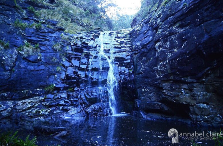
Halfway through, it hit me. I was going home. I didn’t really want to go home (even if it was just for a weekend), other than to see my family for hugs and kisses and maybe a hot cross bun or two (or five). I wasn’t quite ready to be back in my old room, back in that old routine. So I thought I better get a wriggle on with making plans to keep myself busy. That’s when Lesmurdie falls came to mind. I hadn’t had a chance to visit them before I left my home town, and what better way to spend some quality time with Mum than on a bush hike? I’m not sure she agreed, but I dragged her along anyway.

How to get there: 

Lesmurdie is located in the Shire of Kalamunda, also known as ‘Up in the Hills’ in Perth jargon. It’s practically the only part of Perth that isn’t deadpan flat. But anyway. The falls are in Lesmurdie – hence Lesmurdie Falls (thanks captain obvious), and are relatively easy to get to.

They are best accessed from Welshpool Road East, or Kalamunda Road, depending on where you are coming from. I’ve only outlined Welshpool Road directions because it’s the way we went.

Road Map to Lesmurdie Falls. Google Maps (2017).

From Welshpool Road:
Right or Left (depending which way you’re travelling) into Gladys Road.
Left into George Road.
Follow George Road as it curves around to the right, until you reach Ford Road.
Turn left onto Ford Road.
You’ll reach a fork in the road.
Turn right onto Nelson crescent.
Follow Nelson crescent until you hit Falls road.
Turn left into Falls road – this will be a ‘No Through Road’, but you’ll see the carpark before you reach the dead-end.
Congrats! You’ve arrived! See? Easy.

So Mum and I arrived. Up at the top of the falls, we had a steep descent ahead of us. There are a few hiking trails to choose from, the sign at the beginning of the trail will show you where each one goes and how long it will take. After a little uhmming and ahhing, we decided to take The Falls Trail – only a 640m return. I desperately wanted to manoeuvre to the bottom of the falls to watch them flow, and The Foot of the Falls trail is a continuation of The Falls Trail, so that was a win-win for me.

The walk is a relatively easy one, and we made our way leisurely, following the signs along the way. Luckily, you don’t have to be a rocket scientist to find your way to these falls. Soon enough, we reached the peak where the view overlooking Perth and the city is simply phenomenal. If anything, you should visit these falls to stare out at that.

It was 27 degrees but it felt more like thirty-something as we walked, sweat trickling down my back between my backpack and my shoulder blades. There wasn’t a whisp of wind in the air, but you couldn’t complain about the weather. Not when it produced views like this.

There are two lookout spots made of metal frames –  what I assume is the end of The Falls Trail. We reached these and peered down at the valley from the top of the waterfall. The falls were fairly dry, a testament to this time of the year in Perth. We were lucky they were flowing at all, really, probably due to the heavy rainfall which recorded the wettest day ever in February.

Photo taken in April 2017

I tried my best to get good photographs of the falls, which undulate down the steep slopes. I ventured further down the pathway, stepped onto precarious rocks and bent my knees in typical ‘photographer’ stance. But it was no use, the lighting wasn’t doing the scene any justice. So we made the split decision to continue to The Foot of the Falls (2km return).

If you don’t like stairs, this trail is definitely not for you. Wide wooden steps of orangey-red dirt lead the way towards the bottom of the falls.

A thin, dry, gravel path then winds its way through shrubs, seemingly taking you in the complete wrong direction. Trust me, you’re headed the right way.

Soon, we reached a fork in the road and pondered over the huge descent. Hint: you want to follow the path down to the right, until you pass another carpark. There wasn’t any signage at this point, so it was a bit of a gamble. I guess it’s all part of the adventure.

My shoes kept slipping on the gravel and we giggled amidst a series of “Did you have a nice trip?” and “You didn’t send me a postcard!” But in all seriousness, maybe wear some shoes that have a bit of grip to them. Apparently my old sneakers have decided they’ve had enough of being grippy.

Finally, we reached the smoother path that resides next to the riverbank, listening to the calm trickle of water as it gradually became louder. I skipped with excitement – we were almost there.

It seemed as though the windy river would never end. Animals rustled the bushes nearby, bees hummed in the distance. We took it all in as we walked.

I love how every time you go on a nature walk, it will never be the same again. Things are ever-changing, and that’s what makes the experience so worthwhile. You just have to stop when you’re going to admire things, otherwise you can’t see the uneven ground below you and you’ll end up tripping again. Which is embarrassing, trust me.

Just when I thought we’d never make it, BOOM, there they were. Lesmurdie Falls. We could see the lookouts that we had come from, and thin sprays of water flowing down the rock-face, which is a lot steeper than it looks in photographs.

I tip-toed over cobbled rocks like stepping-stones, working my way towards the water. Mum was less eager, but eventually found her way. Our glutes were sore, our shoulders were red & raw (sunscreen: would recommend) and we were puffing, deep breaths from our lungs. We chugged down water that had warmed inside our plastic bottles. But we had made it.

There’s something triumphant about finally finding the falls. It’s like the reward you get for doing some damn hard-work. You can sit, or stand, and admire them for a little while, taking it all in and congratulating yourself for making it.

Or, if you’re like me, you can kick off your shoes, toss out your hair and jump straight under the fresh, clean water – fully clothed, might I add. Yeah, I’m crazy. But it was hot, and we’d made it this far. I wasn’t about to leave without experiencing the falls first-hand.

The water flow was stronger than I realised, and I had to carefully slide myself along mossy, slippery rocks, feeling for secure cracks and dips for my feet to rest. It’s dangerous, don’t get me wrong, but it’s a thrill I can’t replace. Ironic really, since I can’t even sit on an aeroplane without freaking out. It’s far more dangerous to climb slippery, rocky slopes than it is to sit on an aircraft. But I digress.

The icy cold water soaked me through – I just laughed and spluttered and threw my arms in the air, feeling the rush of water clean out my fingernails and wash through my hair.

It certainly cooled me off for the trek back to the top. And boy oh boy, a trek it was. You forget when you’re going downhill that you’ll have to go back up. My wet clothes clung to me and kept me from overheating, trudging uphill for what felt like forever (my iPhone tells me it was 30 flights of stairs, but who knows how accurate that really is). We made it, though, obviously, or I wouldn’t have lived to tell this tale. But it was worth every step.

I have since returned to Lesmurdie Falls in October, and they look mighty different after winter! Check out the pics below!

Quick Facts

Last visit October 2017
Best Time July-September
Start / Finish Lesmurdie Falls Carpark
Unsealed Roads No
Walking distance Falls Trail 640m return, Foot of Falls 2km return
Time Allow 2hrs
Difficulty Moderate
Facilities Picnic tables, Toilets
Lat & Long 31.9943° S, 116.0337° E
Nearby Shire of Kalamunda
Watercourse Lesmurdie Brook

Want to subscribe?

Never miss out on a waterfall chase by entering your email below!

Recent Posts

Find me on Facebook