Swallow Cave Falls (Upper Sheoak Falls)

Swallow Cave Falls (or Upper Sheoak Falls), Great Ocean Road, Lorne – Victoria, Australia

I’d been to Sheoak Falls twice before I finally ventured further up towards Swallow Cave. Don’t ask me why, because I honestly don’t know. I won’t pass up the opportunity again.

Swallow Cave Falls (Upper Sheoak Falls)

Swallow Cave isn’t referred to as a seperate waterfall, because really it’s just the Upper part of Sheoak Falls. On the way to Sheoak Falls, there’s the option to head up a staircase on the left side, instead of walking down to the right. 

It’s here that leads to Swallow Cave.

There are quite a few stairs, with sections of flat path in between.

It’s not long before the first viewing platform appears, allowing an amazing view of what I’m calling “Swallow Cave Falls.”

Image of Swallow Cave Falls (Upper Sheoak Falls) during Chasing Waterfalls trip to Lorne

But the journey doesn’t end there. The rocky, tree root infested path continues on.

Although the cliffs in this area can be dangerous, so stick to the paths.

Which shouldn’t be hard, as the track is clearly signposted.

This track can actually continue on to Castle Rock, a rock formation on the way to Won Wondah Falls and Henderson Falls.

Yet another reminder of the danger surrounding the track…

And then the track hits the river. After extremely heavy rainfall, it would be impossible or extremely dangerous to cross.

Luckily when I visited, it wasn’t too high. Plus I was wearing my Hunter Gumboots, though they actually filled with the freezing cold water as I crossed. But I digress.

The river will look similar to this if it is safe to cross. It’s up to your judgement of how fierce the water flow is and your level of confidence.

So I carefully made my way across the river, and trudged up the muddy bank on the other side. 

Here, more signs indicated back the way I had come (presumably for hikers who began their journey at either Phantom Falls or Henderson and Won Wondah Falls, a total of 8kms or so). 

Then the signs relevant to me – indicating Swallow Cave, only 100 meters away. 

The track leads down to another viewing platform, which can be seen from the first viewing platform on the opposite side of the river.

But that wasn’t quite enough for me. I decided to take a risk and venture down the left hand side of the platform to get closer to the falls. 

I took extra care. I didn’t take any further risks by going closer to the cliff drop. The falls near Swallow Cave are relatively flat, and I made sure I only stood on dry rock. The wet rock is far too slimy and dangerous. So I don’t recommend this unless you stay far, far away from the sheer drop. 

Other than that, it was a beautiful spot to relax and watch the Swallows flit about in the air. 

I enjoyed visiting Swallow Cave Falls, because even though they were so close to Sheoak, and by no means hidden, they felt secret. They were special and unique, and involved the perfect amount of adventure to find. 

Quick Facts

Last visitSeptember 2017
Best TimeJune-Sept 
Start / FinishSheoak Carpark, Great Ocean Road 
Unsealed RoadsNo 
Walking distance Roughly 1km or less (from carpark)
Time 30mins
DifficultyModerate (stairs and river crossing involved) 
FacilitiesNone 
Lat & Long Sheoak Falls: 38.5653° S, 143.9628° E
NearbySheoak Falls, Won Wondah Falls, Henderson Falls, Phantom Falls 
Watercourse Sheoak Creek

Want to subscribe?

Never miss out on a waterfall chase by entering your email below!

Recent Posts

Find me on Facebook

Carisbrook Falls visited during Chasing Waterfalls trip in Lorne

Carisbrook Falls, Great Ocean Road, Skenes Creek – Victoria, Australia

Though the viewing platform to Carisbrook Falls is a mere 500 meters from Great Ocean Road, once you’re there, you feel like you’re in a different realm. They appear, cascading down a rock face that seemingly comes out of nowhere amidst an abundant green terrain.

Carisbrook Falls visited during Chasing Waterfalls trip in Lorne

The short trail to Carisbrook Falls begins from a gravel carpark that veers off from Great Ocean Road, roughly halfway between Lorne and Skenes Creek. 

The carpark is uneven, so take it slow to avoid an extra bumpy ride. 

The beginning of the trail is clearly signposted.

Follow the track uphill, ignoring blocked off deviations such as this one. 

I visited Carisbrook Falls on my way home to Melbourne from Skenes Creek, after a 4 day Chasing Waterfalls Trip. (Itineraries for my days can be found here – Day 1 and here – Day 2). So I was exhausted. And I couldn’t imagine a waterfall being visible from here.

But I continued on. Soon I saw a river gushing far below in the valley, which gave me confidence.

I shifted my backpack, tugged my camera bag comfortably over my shoulder, and continued on. The path was short, but thin and steep. 

And sure enough, soon I saw the falls peeking through the trees.

The tiny viewing platform is quite some significant distance from the falls, but still breathtaking. Best visited after heavy rainfall, such as the case on the day I visited, the water gushes down the mountainous terrain. 

Carisbrook Falls were a pleasant, short walk with a rewarding result. I’m glad I gathered the last of my strength to pay them a visit. 

Quick Facts

Last visitSeptember 2017
Best TimeJune-July
Start / FinishCarpark off Great Ocean Road, Wongarra
Unsealed RoadsNo, carpark road a bit bumpy 
Walking distance500meters one way
Time40 minutes return
DifficultyEasy
FacilitiesNone, halfway between Lorne and Apollo Bay
Lat & Long38.6919° S, 143.8098° E
NearbySheoak Falls & Swallow Cave
WatercourseCarisbrook Creek

Want to subscribe?

Never miss out on a waterfall chase by entering your email below!

Recent Posts

Find me on Facebook

Little Aire Falls visited on a Chasing Waterfalls trip to Apollo Bay

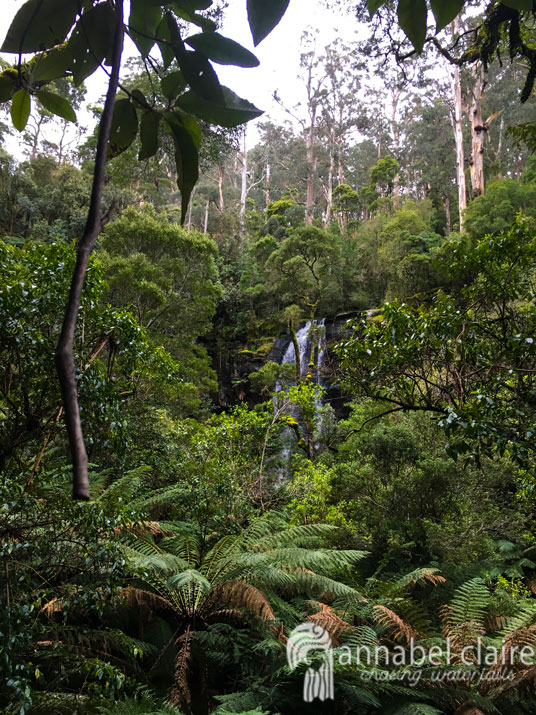
Little Aire Falls, Beech Forest, Great Otway National Park, Apollo Bay – Victoria, Australia

Little Aire Falls are worth the deviation after visiting Triplet Falls. That’s all I needed someone to tell me before I began the trek. But they didn’t, so I set out to find them, not knowing what to expect.

Little Aire Falls visited on a Chasing Waterfalls trip to Apollo Bay

After about 200meters along the track to Triplet Falls, there is a sign to Little Aire Falls. It is advised as 2.3kms, which seems easy enough. So I set off. 

The track begins thin and flat, winding its way through the beautiful forest.

It was all but quiet, the soft padding of my gumboots on the dirt and the wind rustling in the trees the only prominent sounds around me.

I then reached a staircase and metal walkway, similar to those on the Triplet Falls trail.

At this point I thought the track was quite easy. However, it soon began to undulate, up, down, up down, as it wound its way through the forest. It wasn’t long before I was puffing, the all too familiar burning sensation returning in my legs.

Lengthy sections of this trail are not signposted, with plenty of steep uphills and downhills. 

After 20 minutes or so, I hadn’t seen another soul. It was so quiet, I wondered if I was heading in the right direction. But soon I reached a small clearing with a wooden post.

I presumed it meant I needed to continue straight. But who knew?

At times, the tracks are weathered and unclear. My anxiety came roaring to the surface as the day ticked on towards the later afternoon. I wanted to make it back to Skenes Creek before dark. But I was also determined to find the falls.

I soon became stressed, glancing above at the sky, and losing energy during the steepest sections.

I seriously considered giving up and turning back, because I felt it had been further than 2kms already. My iPhone’s health tracker indicated that it had – though I had no phone service so this could have been inaccurate. But then I saw a sign. 

So I continued on, walking through the deathly quiet forest. The sky became more overcast, and the track darkened. I quickened my pace, eager for it to be over.

It was a welcome relief when I emerged from the trees, following another sign through to an open section of the trail. 

The presence of signs kept increasing here, which restored my confidence. I felt my anxiety fading away. I wasn’t on a wild goose chase after all. 

More steps appeared; more reassurance that the track was reliable.

There were quite a few stairs. My legs ached with each step. But soon I saw a metal bridge appear at the bottom and my heart leapt. Had I made it?

Sure enough, I had made it to the viewing platform, where the falls were roaring many meters below. 

I almost jumped with joy, pumping my fists into the air. I even took an Instagram video explaining my hectic hike and my happiness at the end result.

Sure, it was disappointing that there was no access to the base of Little Aire Falls, but the view was still magnificent. And luckily I have a 300mm camera lens which allowed me to zoom in and capture the detail of the falls in their immense full-flow.

I took the time to sit and admire the falls. Partly because I was exhausted, and partly because they were so beautiful. I munched on a banana and a muesli bar to recharge, and longed to be closer to the falls. 

But in all honesty, I wouldn’t have changed the hike for the world. I just wish I’d had more accurate information about the hike. It definitely felt longer than 2.3kms. But that’s why I do what I do – to help others and let them know exactly what’s in store. So be prepared for a lengthy, strenuous hike to Little Aire Falls, which at times will feel like you’re in the wrong place. I assure you, you’ll get there in the end. 

Quick Facts

Last visitSeptember 2017
Best TimeJune-September
Start / FinishPhilips Track Rd Carpark
Unsealed RoadsYes, average condition but manageable with 2WD
Walking distance5kms return to a viewing platform quite some distance from the falls NO ACCESS to base
Time3.5hrs return (if deviate to Triplet Falls, otherwise 2-2.5hrs)
DifficultyStrenuous, lots of steep undulating uphill and downhill
FacilitiesToilets and Picnic Tables
Lat & Long38.6685° S, 143.4937° E
NearbyTriplet Falls, Hopetoun Falls, Beauchamp Falls
WatercourseYoung Creek

Want to subscribe?

Never miss out on a waterfall chase by entering your email below!

Recent Posts

Find me on Facebook

Upper Kalimna Falls during Chasing Waterfalls trip to Lorne

Upper Kalimna Falls, Great Otway National Park, Lorne – Victoria, Australia

Upper Kalimna Falls during Chasing Waterfalls trip to Lorne

Upper Kalimna Falls are the less impressive of the Kalimna’s, but worth visiting nonetheless. Just 2km further on from Lower Kalimna Falls, the trek begins from the Sheoak Picnic Area (pictured below).

If you’ve read my post on Lower Kalimna Falls, you’ll know that the track begins from behind the carpark. In front of the carpark are tracks to Henderson Falls and Won Wondah Falls.

I won’t go into detail about the track – all information can be found in the Lower Kalimna Falls blog post.

Once at Lower Kalimna Falls, a sign (pictured below) next to the track indicates Upper Kalimna Falls.

Here, the track becomes thinner, though still quite muddy if there’s been recent rainfall. The sunny day I had been experiencing was beginning to take a turn, so I hurried along.

The track then became even thinner, and I had to take extra care to avoid slipping.

After a short while, a glimpse of Upper Kalimna Falls peeked through the trees.

The muddy path turned into a leafy-covered mess that was extremely slippery. This has obviously been an issue in the past, with rubber laid on this section to try and provide grip. However, it wasn’t very effective. I recommend wearing appropriate footwear. Luckily, I was wearing my Hunter gumboots which are not only waterproof, but also have ribbed soles for extra grip. 

The final leg of this walk is on a wooden boardwalk covered with metal mesh to help prevent slipping. This boardwalk goes right up to a dead-end where there is a viewing platform for the falls. 

Droplets of rain began to seep from the sky, so I quickly snapped a shot of the falls and made my way hastily back to the carpark. I didn’t beat the rain, though, and ended up being caught in it. Thankfully, I had my Kathmandu raincoat and thick yellow raincoat from Bunnings to keep me and my gear dry. Read more about them/what to take on a waterfall adventure here. 

I still really enjoyed Upper Kalimna Falls. If you’re trekking to Lower Kalimna Falls and have some extra time, I don’t see why you wouldn’t pay them a quick visit. 

Quick Facts

Last visitSeptember 2017
Best TimeJune-September 
Start / FinishSheoak Falls Picnic Area (lower carpark)
Unsealed RoadsYes, average condition but manageable in 2WD
Walking distance8.5km return (Lower Falls on the way) extremely muddy after rainfall, gumboots recommended
Time3.5hrs return
DifficultyModerate (easy but far distance)
FacilitiesToilets, Picnic Tables and Shelter at Sheoak Picnic Area
Lat & Long38.5618° S, 143.9090° E
NearbyLower Kalimna Falls, Henderson Falls, Won Wondah Falls, Phantom Falls
WatercoursePart of Little Sheoak Creek

Want to subscribe?

Never miss out on a waterfall chase by entering your email below!

Recent Posts

Find me on Facebook

Olinda Falls, Dandenong Ranges National Park, Melbourne – Victoria, Australia

It was a Saturday morning.

My schedule? Assignments, assignments, and OH YEAH – more assignments. It was not in the plan to even leave the house. 

I peered longingly out of my bedroom window. It was sunny outside, a rare occurrence at this time of the year in Melbourne. Extremely rare. In fact, it almost never happened…

So, I made a split-second decision.

“Stuff it,” I thought, “It’s such a beautiful day, I’m not going to waste it.”

So, I put on my hiking gear and I packed a bag, locked the door behind me, and off I went on my adventure.

And an adventure it was. You see, I don’t own a car. That’s because I live in Melbourne and the public transport here is pretty good. That is, if you’re just travelling within the city. Where I was headed – the Dandenong Ranges – was practically the country-side.

SPOILER ALERT: I made it. Lol.

It took me (from Brunswick):

  1. The 19 tram from Brunswick Road/Sydney Road to Melbourne Central Station.
  2. The Lilydale Train line to Croydon (21 stops).
  3. The 688 Bus to ‘Upper Fern Tree Valley’ from Stop 6 outside Croydon station (which was actually super easy to find), then getting off after 37 stops. Thirty Seven! At Dandenong Tourist Road/Falls Road. Make sure to look up the latest routes on Public Transport Victoria, or download the PTV app.
  4. A 1.1km walk down a tremendous hill that is Falls Road (which I forgot I was going to have to walk back up. Ha. Ha. Ha….)
  5. I arrived! With total travel time at 2hrs 11minutes. The above photograph is outside the carpark – the track to the falls is off to the left.

There’s a lovely little picnic area here, as well as plenty of signage to help you on your way. I forgot to get a photograph of the map because a group of tourists were milling around it when I arrived, so I figured I’d get the shot on the way back. Of course, I forgot. Sorry everyone.

There’s also toilet facilities, which aren’t drop toilets but are still pretty dismal, and which only had freezing cold tap water.

The track to the falls is quick (roughly 300m), and all downhill.

Off I went, through an array of gorgeous Karri trees.

There are also a number of other walking tracks in this area for those that are keen hikers. Me? I’ll only hike if it will find me a waterfall. But if you want more information on the hikes in area, you can click here.

Then I reached the fork in the road with the track to the Lower Falls one way and the Upper Falls the other. You’d think my heart would’ve sunk at the sight of the fence blocking off the Lower Falls track, wouldn’t you?

In actual fact, I didn’t even bat an eyelid. I knew full well I’d be going down there regardless. I didn’t come all this way for nothing. But I decided to check out the Upper Falls first.

On the short walk to the Upper Falls, a little path had formed itself down the river bank. I knew I’d be scooting on down there, too. However, a little further along there’s a viewing platform, from which you can get some pretty gorgeous shots, too.

Still, typical me found my way as close to the water as humanely possible. I can imagine that in the crux of winter, it would be impossible to walk across the rocks like I did. At this time (May on the cusp of June) it was relatively tame.

I spent quite a bit of time meandering across the rocks to get some shots at different angles. It was a very peaceful day, with not too many people around, so I wasn’t disrupting anyones photographs.

I then decided it was time to venture further into the ‘exclusion zone’. I had planned to walk back up the path and squeeze past the fence, but a fallen log near the platform lookout of the Upper Olinda Falls allowed access to the blocked-off path. I wobbled across it and appeared with a view of the fence behind me. I know – #DareDevil #Rebel

There was a steep descent ahead of me, and I felt my heart clanging around in my chest. What challenge awaited me? Why had the path been blocked off? I was about to find out.

It was a bit anti-climatic, really. I thought I was going to have to scramble over huge fallen trees and debris and stuff. Turns out it was just the side railing that had been destroyed. The path itself was fine. I know, boring right?

Tis’ pretty hectic damage, though. But I continued on just fine without the aid of the railing. I guess if it had been a wet, rainy day it would’ve been more dangerous. Travel at your own risk, I guess.

Before long I came to a fork in the road – which was actually three seperate paths, marked with a wooden stool, a big tree and more hand-railing.

Path number 1 veers off to the right:

Path number two veers off to the left, down some steps which are just planks of wood and then mud:

And path number three, which isn’t really a path, so much as it is a slope made clean by rainwater, is straight ahead:

I decided to veer right first, in an attempt to get closer to the Upper Falls. I had peered down at them from the top viewing platform, aching to go further down and get better angles for photos. I hoped this path would lead me there.

Success! I managed to find the endless cascades of the Upper Falls, and a thin path along the right of the river bank made it easy to walk along and get closer.

As you can imagine, with heavy rainfall in the midst of winter this may not be accessible. It kind of reminded me of The Lion King 2, when the river suddenly gushes and fills with water, covering everything in its path. But luckily for me, my fate was less drastic than Zira’s. If you don’t know what I’m talking about, you need to go and watch The Lion King 2 right now. Like seriously, quit reading this and go watch it.

Anyway, then I ventured back to the fork in the road (where the wooden seat was) and tackled the path that wasn’t really a path, slipping and sliding my way down (literally, this was dangerous so be very careful if you plan on doing this).

The difficulty was rewarding, however, when I reached some mini-falls. These were probably my favourite along the entire bank.

Now, because I still haven’t invested in a tripod (give me a break – I’m a broke uni student!), I had to rest my camera precariously on slippery rocks. It actually almost slid off once, but I caught it. Thankfully. The mini heart-attack I had when that happened was enough for me to give up on the photographs.

However, before that little incident, I managed to capture some shots on self-timer.

I look pretty relaxed, hey? Haha don’t be fooled – my camera’s self-timer only allows up to 10 seconds of delayed photography, so I had to sprint (on slippery mud) and leap over the rock on the right-hand side – yeah, the one covered in the green moss – in order to get to that spot.

Green mossy rock^^

And there I am wearing my Lu Lu Lemon Top which makes me look like I have horrendous back-fat. But IT’S FINE. I GOT THE PHOTO. Anyway this was the last shot I took before I almost lost my camera down the stream of freezing water, so I made my way back up to the main path.

P.S. If anyone wants to be my hiking/waterfall buddy and take aesthetic photos of me, don’t be shy! Enquire within.

I then started the short journey to the Lower Falls along a thin, muddy path. All in all, the difficulty rating of this track is relatively easy.

I continued on, down a windy section of the path that veered around to the right and opened up into the Lower Falls platform.

It was peaceful, seeing as the path was blocked off, and I had the place to myself.

As you can see, the falls keep going further downstream. I wondered what they look like from here on. But the access ends here, so I will never know. Luckily, the Lower Falls were beautiful and distracted me.

I rested my camera on the ledge of the platform to achieve these shots (don’t worry, this time I kept the strap around my neck and didn’t abandon the camera, so there was no chance of it falling to a cold, wet death).

Again, further up there were some more mini-falls. I simply loved experimenting with photos, and taking in all the beautiful surroundings and the different nooks and crannies of this waterfall. I really am surprised they don’t refer to them as cascades.

Overloading you with photographs just to try and spark some inspiration in you. I highly recommend going to visit!

Plus the Dandenong Ranges itself is a beautiful area of Victoria. I felt the air turn chilly and crisp the moment I arrived. But it was amazing – clean, fresh air free from all the city’s pollution. I was relieved to be free of cigarette smoke, if even for a little bit.

Quick Facts

Last visit May 2017
Best Time June-October
Start / FinishDandenong Ranges National Park Carpark
Unsealed Roads No
Walking distanceUpper 350meters Lower 500meters
Time 1hr return
Difficulty Moderate
Facilities Picnic tables, Toilets
Lat & Long 37.8341° S, 145.3700° E
NearbyDandenong Ranges Botanic Gardens
Watercourse Olinda Creek

Want to subscribe?

Never miss out on a waterfall chase by entering your email below!

Recent Posts

Find me on Facebook