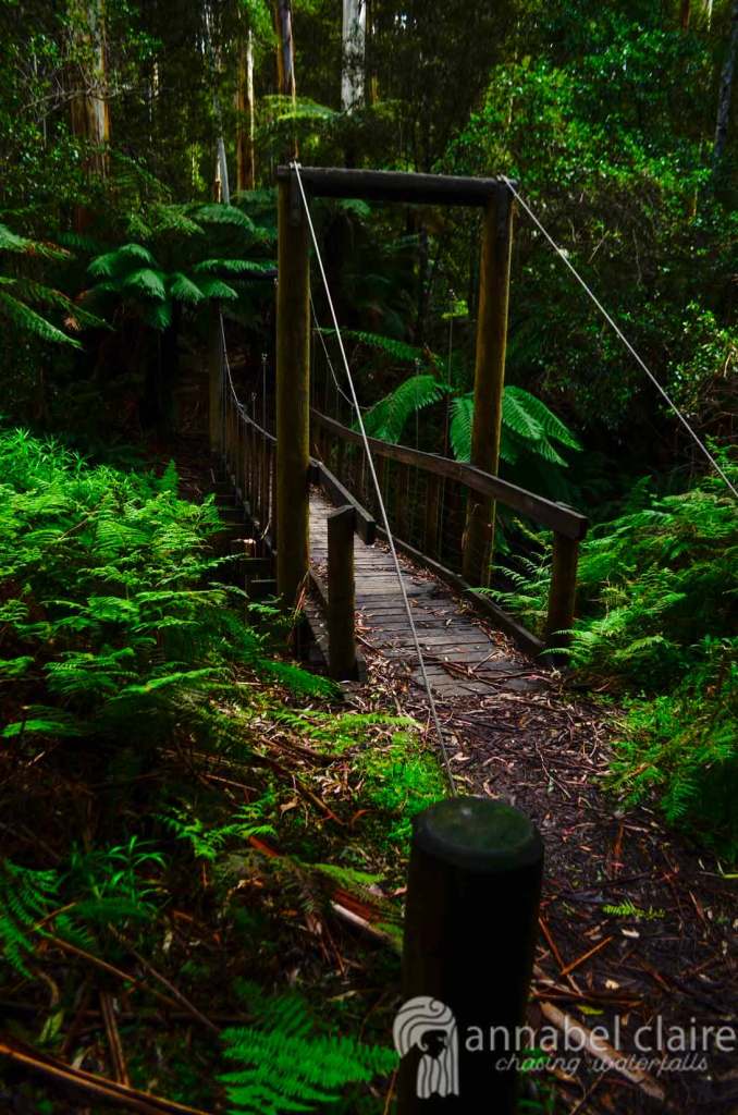
Upper Kalimna Falls during Chasing Waterfalls trip to Lorne

Upper Kalimna Falls, Great Otway National Park, Lorne – Victoria, Australia

Upper Kalimna Falls during Chasing Waterfalls trip to Lorne

Upper Kalimna Falls are the less impressive of the Kalimna’s, but worth visiting nonetheless. Just 2km further on from Lower Kalimna Falls, the trek begins from the Sheoak Picnic Area (pictured below).

If you’ve read my post on Lower Kalimna Falls, you’ll know that the track begins from behind the carpark. In front of the carpark are tracks to Henderson Falls and Won Wondah Falls.

I won’t go into detail about the track – all information can be found in the Lower Kalimna Falls blog post.

Once at Lower Kalimna Falls, a sign (pictured below) next to the track indicates Upper Kalimna Falls.

Here, the track becomes thinner, though still quite muddy if there’s been recent rainfall. The sunny day I had been experiencing was beginning to take a turn, so I hurried along.

The track then became even thinner, and I had to take extra care to avoid slipping.

After a short while, a glimpse of Upper Kalimna Falls peeked through the trees.
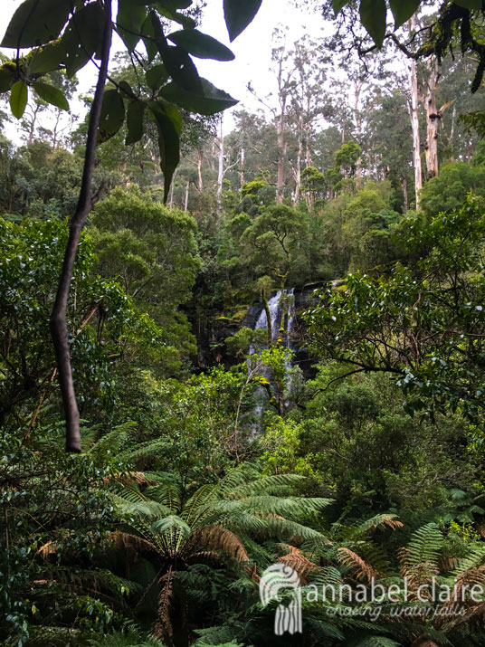
The muddy path turned into a leafy-covered mess that was extremely slippery. This has obviously been an issue in the past, with rubber laid on this section to try and provide grip. However, it wasn’t very effective. I recommend wearing appropriate footwear. Luckily, I was wearing my Hunter gumboots which are not only waterproof, but also have ribbed soles for extra grip. 

The final leg of this walk is on a wooden boardwalk covered with metal mesh to help prevent slipping. This boardwalk goes right up to a dead-end where there is a viewing platform for the falls. 

Droplets of rain began to seep from the sky, so I quickly snapped a shot of the falls and made my way hastily back to the carpark. I didn’t beat the rain, though, and ended up being caught in it. Thankfully, I had my Kathmandu raincoat and thick yellow raincoat from Bunnings to keep me and my gear dry. Read more about them/what to take on a waterfall adventure here. 

I still really enjoyed Upper Kalimna Falls. If you’re trekking to Lower Kalimna Falls and have some extra time, I don’t see why you wouldn’t pay them a quick visit. 

Quick Facts

Last visitSeptember 2017
Best TimeJune-September 
Start / FinishSheoak Falls Picnic Area (lower carpark)
Unsealed RoadsYes, average condition but manageable in 2WD
Walking distance8.5km return (Lower Falls on the way) extremely muddy after rainfall, gumboots recommended
Time3.5hrs return
DifficultyModerate (easy but far distance)
FacilitiesToilets, Picnic Tables and Shelter at Sheoak Picnic Area
Lat & Long38.5618° S, 143.9090° E
NearbyLower Kalimna Falls, Henderson Falls, Won Wondah Falls, Phantom Falls
WatercoursePart of Little Sheoak Creek

Want to subscribe?

Never miss out on a waterfall chase by entering your email below!

Recent Posts

Find me on Facebook

Lower Kalimna Falls taken on Chasing Waterfalls trip to Lorne, Victoria

Lower Kalimna Falls, Great Otway National Park, Lorne – Victoria, Australia

Lower Kalimna Falls taken on Chasing Waterfalls trip to Lorne, Victoria

One of the most unique waterfalls in Lorne is Lower Kalimna Falls. Photographs I had seen made me giddy with excitement as I begun my journey from Sheoak Falls Picnic Area. 

Unlike when heading to Won Wondah Falls and Henderson Falls, the track to Lower Kalimna Falls (and Upper further along) begins on the opposite side of the carpark (behind it). 

If you decide to venture to Won Wondah Falls and Henderson Falls, the track to Lower and Upper Kalimna Falls intersects, however this was closed when I visited due to recent weather. However, trekking from this track would make your journey much longer anyway, so you’re better off beginning from the carpark.

The track that begins from the carpark is also subject to weather conditions, and this warning sign at the beginning made me thankful I had chosen to wear my Hunter Gumboots.

Not long after beginning, the reality of the sign was quite clear:

So I shouldn’t have to stress enough: take care when walking on tracks like these. 

As you can see, though, aside from some debris and weather damage, the walk is quite flat and easy. I crossed the first bridge with ease.

Squelching through the mud actually became quite fun, especially since the sun was out and shining through the trees.

The river gushed past as I continued on.

I then came across what I presume was the reason the connecting track to Henderson and Won Wondah Falls was closed: A friendly reminder that nature can be very dangerous.

At this point, Lower Kalimna Falls are only 1.5kms further, and Upper another 2.6kms. I’m not quite sure how accurate these distances are, though, because the trek felt extremely long to me.

It was fascinating to learn how old this track really is, particularly the old tramline track. The sign indicates that the physical remains of such infrastructure is “rapidly decaying.” It made me shiver.

But, a bridge in much newer condition restored my confidence in the track.

More fresh, flowing water was also a good sign that I was getting closer.

And sure enough, I hit a muddy fork in the track, where Upper Kalimna Falls continue straight ahead, and Lower deviates to the right.

It’s a short, slightly slanted track down to Lower Kalimna falls, which soon appear magnificent through the ferns.

I was mesmerised with these falls, as I always am when a cave has been eroded behind a waterfall.

I stood in my gumboots and raincoat, underneath the powerful flow of water. I’ve seen photos of this place during drier months, and they’re nowhere near as incredible, so I highly recommend visiting from June-September after rainfall. 

After admiring the falls for some time, I headed further for Upper Kalimna Falls. Head there with me!

Quick Facts

Last visitSeptember 2017
Best TimeJune-September
Start / FinishSheoak Falls Picnic Area (lower carpark)
Unsealed RoadsYes, average condition but manageable in 2WD
Walking distance6.5km return (Upper Falls 8.5km return)
TimeAllow 2.5hrs (3.5hrs if Upper)
DifficultyModerate (easy but far distance)
FacilitiesToilets, Picnic Tables and Shelter at Sheoak Picnic Area
Lat & Long38.5621° S, 143.9167° E
NearbyUpper Kalimna Falls, Henderson Falls, Won Wondah Falls, Phantom Falls
WatercoursePart of Little Sheoak Creek

Want to subscribe?

Never miss out on a waterfall chase by entering your email below!

Recent Posts

Find me on Facebook

Henderson Falls taken during Chasing Waterfalls trip to Lorne, Victoria

Henderson Falls, Great Otway National Park, Lorne – Victoria, Australia

Henderson Falls taken during Chasing Waterfalls trip to Lorne, Victoria

If you’ve read my post on Won Wondah Falls, you’ll pretty much know how to get to Henderson Falls. You might want to skip down to the part that continues on from Won Wondah, because there’s some essential pre-knowledge required. If not, your journey begins right here. At Sheoak Falls Picnic Area.

The carpark is accessed via an unsealed road which is in average condition, though my Suzuki Swift hire car managed just fine. 

From the carpark, continue straight towards the picnic area.

You’ll know you’re in the right direction because you’ll see the below signs.

Head along the flat, earthy path towards the thick trees.

Be sure to stop along the way and view the nature signs along the way. You’ll be admist a fern paradise – take it all in. 

Crossing a small wooden bridge, this track is pretty easy.

Though it becomes dark at times in the thick, green ferns. I had to duck my head under them, carefully holding fronds out away from my body.

Thankfully, the path is well signed and easy to follow.

The nature walk is a loop which can be exercised here, though my friend Brad and I continued toward the road.

Once we hit the road, the track continued up to the left for Lower Kalimna Falls and Upper Kalimna Falls, and to the right for Won Wondah Falls and Henderson Falls.

Obviously we continued to the right, with Won Wondah Falls a mere 1km away, and Henderson a further 500 meters from there.

Walking with ease past bright yellow Australian wattle, it was a pleasant trail.

Soon we reached another intersection, at which point the signs indicate to continue straight.

Another sign told us we were headed the right way.

Arriving at the slight deviation to Won Wondah Falls was a sign indicating that the track continues to Henderson Falls and the Canyon. 

After a brief pitstop at Won Wondah Falls, we continued this way.

While it looks like a flat, easy track, it was actually extremely muddy.

Follow the signs for Henderson Falls.

Soon the mud became thicker. It was very wet, squelchy and deep. I was thankful I had chosen to hike in my Hunter gumboots, and would highly recommend a similar choice. Lorne often experiences high rainfall, especially in the winter time, but even in September the trails were muddy.

Shortly after the muddiest part of the trek, a bridge appeared in the distance.

We crossed it carefully, as the wood was damp and slippery.

The stream trickled by us, which was a good sign.

Finally, one last bridge led the way to the base of the falls.

And they were magnificent. I enjoyed Henderson Falls so much because you could walk right up to their base, shown in the below photo.

I would say September was a perfect time to visit, as the falls were still in full flow, yet not so heavy that you couldn’t walk right up to them. 

I remember the cold spray whisking into the air and landing on my face as I peered up at them.

It was a stunning secluded little spot, and while other tourists did come and go, it was by no means crowded. If I’m being honest, it was probably one of my favourites. But shh, don’t tell the other waterfalls!

After sitting and admiring their beauty, Brad and I headed back towards the Sheoak Falls Picnic area to munch on some food before beginning the long journey to Lower and Upper Kalimna Falls. Click here for Lower Kalimna Falls! And here for Upper Kalimna Falls (Lower are on the way).

Quick Facts

Last visitSeptember 2017
Best TimeJune-September
Start / FinishSheoak Falls Picnic Area (lower carpark)
Unsealed RoadsYes, average condition but manageable in 2WD
Walking distance1.8km one way, very muddy after rain
Time1.5hrs one way
DifficultyRelatively Easy
FacilitiesToilets, Picnic Tables and Shelter at Sheoak Picnic Area
Lat & Long38.5485° S, 143.9337° E
NearbyWon Wondah Falls, Phantom Falls, Lower Kalimna Falls, Upper Kalimna Falls, Sheoak Falls & Swallow Cave
WatercourseHenderson Creek

Want to subscribe?

Never miss out on a waterfall chase by entering your email below!

Recent Posts

Find me on Facebook

Won Wondah falls visited on Chasing Waterfalls trip to Lorne, Victoria

Won Wondah Falls, Great Otway National Park, Lorne – Victoria, Australia

Won Wondah falls visited on Chasing Waterfalls trip to Lorne, Victoria

I’m going to preface this blog post with a revelation I had once I found Won Wondah Falls. You might think it’s fairly obvious – but hear me out. You ready? Here goes.

If you can’t find any great images of a waterfall, chances are it’s because there’s no access to their base, or the viewing platform is obstructed. In the case of Won Wondah Falls, both of these applied.

However, since Won Wondah Falls are a mere pitstop on the way to the more impressive Henderson Falls (which are accessible), there’s no reason not to visit them. 

While Phantom Falls, Won Wondah Falls and Henderson Falls can be completed in an 8.6km loop trail including the Canyon, there is an option to begin at Sheoak Falls Picnic Area which makes the walk much shorter – not to mention easier. This is where my friend Brad and I began the walk. 

From the carpark, walk straight ahead towards the picnic area, where you will find the below sign.

The next sign indicates the various walking trails to choose from. Yes, you can also get to Sheoak Falls from here too, though it’s a much longer walk than if you begin from Great Ocean Road. More on that here. 

We were keen on Won Wondah and Henderson Falls. You’ll notice Won Wondah aren’t signed here, but that’s okay. Continue along the path to the ‘Canyon/Henderson Falls‘. 

This is a flat, easy path that disappears into the trees.

There are plenty of signs about the trails around you, with information about the track and the beautiful wildlife. 

Soon we reached a small bridge, and continued into the thick greenery. 

Needless to say, this place really is a paradise for ferns.

Amongst the ferns, the path becomes dark and magical.

It’s also well signed, so continue towards Henderson Falls.

The nature walk is a loop, so here there’s the option to return to the picnic ground.

Across the road, there are two tracks. 

The first track heads toward the left, continuing to Lower Kalimna Falls and Upper Kalimna Falls, though this was blocked off when we went. (Don’t worry, there is another way, click here for information). 

To the right – Won Wondah Falls first appear on a sign, and Henderson aren’t far behind. As mentioned, you can also continue to the Canyon and Phantom Falls along this trail, however there’s an easier way to Phantom Falls which can be found here. 

Heading to the right, the trail is thin and flat, with tall trees surrounding.

It’s also riddled with native Australian wattle, which brightens the track with its yellow flower.

We reached another intersection, where more signs are conveniently located. Continue straight as advised.

Here, you’re not far from Won Wondah Falls.

Also a good time to mention that unfortunately, bikes and motorbikes are prohibited on these trails. So, slap on your hiking gear and continue forward.

Just a smidgen further, and you’ll reach Won Wondah Falls. The path to Henderson Falls continues straight, while a short path to the right leads to a viewing platform for Won Wondah Falls.

The falls plunge downwards into a valley which is covered by lush vegetation, making it impossible to view or access their base. While still beautiful, the limited viewing makes it difficult to fully appreciate their beauty. 

So we didn’t stay long, soon continuing back up towards the main path and heading to Henderson Falls. Head there with us!

Quick Facts

Last visitSeptember 2017
Best TimeJune-September
Start / FinishSheoak Picnic Area
Unsealed RoadsYes, average condition can be managed in 2WD.
Walking distance1km one way to viewing platform only NO ACCESS TO BASE (further 800meters to Henderson Falls – base access) 
Time30mins one way
DifficultyRelatively Easy
FacilitiesToilets, Picnic Tables and Shelter at Sheoak Picnic Area
Lat & Long38.5500° S, 143.9382° E
NearbyHenderson Falls, Lower Kalimna Falls, Upper Kalimna Falls, Phantom Falls 
WatercourseHenderson Creek 

Want to subscribe?

Never miss out on a waterfall chase by entering your email below!

Recent Posts

Find me on Facebook

Phantom Falls taken during Chasing Waterfalls trip to Lorne, Victoria

Phantom Falls, Great Otway National Park, Lorne – Victoria, Australia

Phantom Falls taken during Chasing Waterfalls trip to Lorne, Victoria

Phantom Falls are a lesser known gem found in Lorne, Victoria. Beginning from Allenvale Mill Carpark (which is awfully difficult to find on Google maps) the walk meanders through a private orchard before heading up a steep gravel track – but the destination is well worth it.  

First up on the agenda was finding Allenvale Mill Carpark – which is actually called Allenvale Road Carpark on Google maps. Nearby is the Allenvale Campsite and other walking tracks (see above and below photos). 

The road to reach this carpark is unsealed, but in relatively good condition. I winced and grimaced every time the hire car went over a bump, but the little Swift made it just fine. 

To begin the walk to Phantom Falls, head down hill, along the gravel road that continues to the right (past the carpark), until you reach the below sign. 

The walk to Phantom Falls is only 3.5km return in total (ignore the sign), however you can choose to continue on a loop that includes Henderson and Won Wondah Falls, though it would take 8.6km in total, including The Canyon (a rock structure with 10 meter sheer faces).

Cora Lynn Cascades can also be reached from this trail, however it is a strenuous hike involving difficult river crossings and should only be attempted by experienced hikers (see my post on Cora Lynn Cascades for an easier route). 

Anyway, my newfound friend Brad and I began along the thin, earthy path to Phantom Falls. 

It was a rather beautiful walk on the sunny September day we were experiencing, and the path follows along the luscious river bank. However, this trail runs through private property, so respect the signage and don’t travel with pets.

Soon we had to cross the river over a small metal bridge.

The track then opens out into the orchid farm. 

Continue to the right and follow the wooden signs indicating a left turn to cut accross the field. 

Here you can see the sheds on the private property, and wooden signs that aid in keeping hikers on track.

The muddy path appears again through the thick grass, and we continued straight.

Wild kangaroos can also be spotted grazing through the trees along this walk.

And maybe a horse or two…

My gumboots squelched in the wet ground as we trudged further along the path – be sure to bring appropriate footwear for these conditions. 

Following the blue stream reassured us we were heading in the right direction. 

Though the track is well signed, so if you follow those you’ll find the falls easily in no time.

I had read that the track was strenuous and uphill, but so far nothing about it rang true. That is, until we hit the gravel road that steadily increased in altitude. 

And suddenly not-so-steadily. My legs began to ache and burn with every step. Sweat dripped off my forehead and into my eyelashes. The photograph below doesn’t even do justice of just how steep this track is. 

And yet the views are simply incredible. Gazing down to the valley below was a great distraction from the difficult ascent.

This photo is taken from the top of the steep slope, looking back down at our achievement. It only lasted for about 500 meters, but it felt much longer. In any case, we had made it. 

After the hill, the track levels out and continues on a relatively straight, flat surface.

Here, you’ve covered 1.6kms and are about to reach Phantom Falls. 

One final sign indicates the other tracks available. Click here for more information on the circuits and hiking trails in the area. 

We continued down to Phantom Falls.

To get to the base of the falls requires a descent down some fairly steep steps, all the while peering down at the gushing stream below. 

Halfway down the stairs, I got my first glimpse of the falls. 

And then we made it. The sunlight streamed in, casting the falls in a dappled light that made for a gorgeous setting. I had to trudge through the freezing, gushing water of the stream to get this shot, water filling my gumboots and soaking my socks. 

But it was worth it, as it always is when it comes to waterfalls. The blue-as-blue water of the river here was simply magnificent, and I would definitely recommend a visit. 

After a while of shooting and a disaster as Brad dropped his camera body and lens into the stream, we decided to head back. Despite the tragedy of the camera, it didn’t take much convincing to get Brad on board to head to Won Wondah and Henderson Falls, however we chose to drive to Sheoak Picnic Area to begin those trails. Click here for Won Wondah Falls! And here for Henderson!

Quick Facts

Last visitSeptember 2017
Best TimeJuly-September
Start / FinishAllenvale Road Carpark
Unsealed RoadsYes, average condition but manageable in 2WD.
Walking distance3.5km return
Time1.5hr return
DifficultyModerate
FacilitiesAllenvale Campsite, Lorne town closeby
Lat & Long38.5432° S, 143.9466° E
NearbyWon Wondah Falls, Henderson Falls, Cora Lynn Cascades
WatercourseSt George River

Want to subscribe?

Never miss out on a waterfall chase by entering your email below!

Recent Posts

Find me on Facebook