Upper Kalimna Falls during Chasing Waterfalls trip to Lorne

Upper Kalimna Falls, Great Otway National Park, Lorne – Victoria, Australia

Upper Kalimna Falls during Chasing Waterfalls trip to Lorne

Upper Kalimna Falls are the less impressive of the Kalimna’s, but worth visiting nonetheless. Just 2km further on from Lower Kalimna Falls, the trek begins from the Sheoak Picnic Area (pictured below).

If you’ve read my post on Lower Kalimna Falls, you’ll know that the track begins from behind the carpark. In front of the carpark are tracks to Henderson Falls and Won Wondah Falls.

I won’t go into detail about the track – all information can be found in the Lower Kalimna Falls blog post.

Once at Lower Kalimna Falls, a sign (pictured below) next to the track indicates Upper Kalimna Falls.

Here, the track becomes thinner, though still quite muddy if there’s been recent rainfall. The sunny day I had been experiencing was beginning to take a turn, so I hurried along.

The track then became even thinner, and I had to take extra care to avoid slipping.

After a short while, a glimpse of Upper Kalimna Falls peeked through the trees.
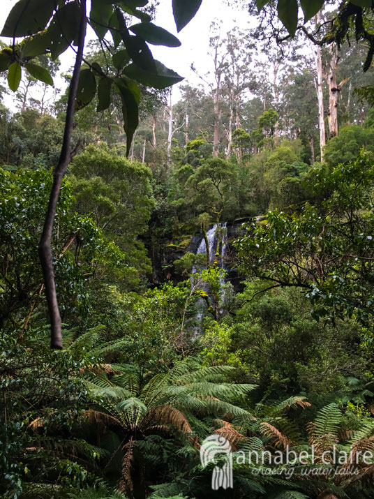
The muddy path turned into a leafy-covered mess that was extremely slippery. This has obviously been an issue in the past, with rubber laid on this section to try and provide grip. However, it wasn’t very effective. I recommend wearing appropriate footwear. Luckily, I was wearing my Hunter gumboots which are not only waterproof, but also have ribbed soles for extra grip. 

The final leg of this walk is on a wooden boardwalk covered with metal mesh to help prevent slipping. This boardwalk goes right up to a dead-end where there is a viewing platform for the falls. 

Droplets of rain began to seep from the sky, so I quickly snapped a shot of the falls and made my way hastily back to the carpark. I didn’t beat the rain, though, and ended up being caught in it. Thankfully, I had my Kathmandu raincoat and thick yellow raincoat from Bunnings to keep me and my gear dry. Read more about them/what to take on a waterfall adventure here. 

I still really enjoyed Upper Kalimna Falls. If you’re trekking to Lower Kalimna Falls and have some extra time, I don’t see why you wouldn’t pay them a quick visit. 

Quick Facts

Last visitSeptember 2017
Best TimeJune-September 
Start / FinishSheoak Falls Picnic Area (lower carpark)
Unsealed RoadsYes, average condition but manageable in 2WD
Walking distance8.5km return (Lower Falls on the way) extremely muddy after rainfall, gumboots recommended
Time3.5hrs return
DifficultyModerate (easy but far distance)
FacilitiesToilets, Picnic Tables and Shelter at Sheoak Picnic Area
Lat & Long38.5618° S, 143.9090° E
NearbyLower Kalimna Falls, Henderson Falls, Won Wondah Falls, Phantom Falls
WatercoursePart of Little Sheoak Creek

Want to subscribe?

Never miss out on a waterfall chase by entering your email below!

Recent Posts

Find me on Facebook

Serpentine Falls – Western Australia, Australia

A small water sanctuary, just South-East of Perth, Western Australia lies Serpentine Falls, where we can frolic and play in nature’s pool.

(Hot Dogs Or Legs? Hehe).

Serpentine Falls are located about 55km South-east of Perth, WA. The drive is quite easy really (approximately 1 hr and 10 minutes from the city), though you may miss the final turn off if you aren’t careful.

If you are coming from Perth City, head straight down Kwinana Freeway. You will then get to turn onto a typically (and hilariously) Aussie-named exit – are you ready for this? – Mundjidong Road, which will eventually reach South Western Highway. (If you’re coming up to the falls from the South, anywhere past the Baldivis kind of area then you will exit the Freeway onto Karnup Road, which also hits South Western Highway.

Either way, turn right onto South Western Highway and if you came from Mundjidong, follow that for another 25km’s or so and you’ll find Falls Road. If you’re coming from Karnup, Falls Road will be right opposite you. Like I said, it’s easy to miss, so be on the look out on your left for a tiny little could-you-even-call-it-that service station, and the Serpentine Park Home Village next door. You’ll find it eventually, trust.

Road Map. Serpentine Falls. Google Maps (2016).

The only not-so-great-thing about these falls is that you have to pay $12 entry if you are in a vehicle. But that goes to maintaining the park, wildlife and facilities. So it’s not so bad, really.

The carpark area is also surrounded by park benches and a picnic area, so it’s a great spot to take some food and friends and enjoy being with nature. Though word of warning – the kangaroos are not shy, and will definitely try and join you.

The Serpentine Park is a great spot for bush walking – and if you’re up for the trek, you can find your way to the top of the falls. But for those lesser inclined to go hiking – you can simply embark on the short, easy walk to the falls pool (off to the right of the overflow carpark area – which is to the left of the picnic area). If you want more info, you can visit The Department of Parks and Wildlife.

Now – to the falls!

The falls are small, but beautiful. A perfect place to relax on the rocks, or glide through the (freezing cold, might I add) water.

If you visit in the summer months, the falls will likely not be flowing very much, or at all. But it is a great time of the year for swimming in the pool. The winter months are an awesome time to see the falls flowing at their full capacity, but it will be far too cold to venture into the water.

Although, I wish I could say that it goes without saying, but it doesn’t: Be Careful. This tiny sanctuary has had 12 deaths due to people underestimating how shallow it really is. So basically, don’t go leaping off the rocks. Simply sit back, be smart, and enjoy the fact that we get to experience these 100 year-old falls in the first place.

Quick Facts

Last visit October 2017
Best TimeNov-Feb for swimming, June/July for water flow
Start / FinishSerpentine National Park Falls Rd Carpark open 8.30am-5pm, plan arrival before 10am. $13 entry for vehicles.
Unsealed Roads No
Walking distance 400meters
Time 5mins
Difficulty Easy
Facilities BBQs, Picnic Tables and Toilets
Lat & Long 32.3679° S, 116.0110° E
Nearby Serpentine Camping Centre, Millbrook Winery
Watercourse Serpentine River

Want to subscribe?

Never miss out on a waterfall chase by entering your email below!

Recent Posts

Find me on Facebook